Each county in Ohio is broken up into (generally rectangularish) townships. Hamilton County has 12 townships. I believe there used to be 14, but Cincinnati Twp and Mill Creek Twp have been completely annexed by the city of Cincinnati. When a county was first formed / surveyed / whatever, it only had these townships as organizational units. As cities and villages are incorporated, land is taken away from the townships to form said cities / villages.
In very urban areas, this can lead to some odd township boundaries, or even removal of the township. As I mentioned before, there are 2 historical townships in Hamilton County that no longer exist. Or Columbia Township which now only exists in several small islands, since the rest of it has been annexed by other cities.
So, the list of places to visit:
Cities:
- Blue Ash
- Cheviot
- Cincinnati
- Deer Park
- Fairfield
- Forest Park
- Harrison
- Indian Hill
- Loveland
- Madeira
- Milford
- Montgomery
- Mount Healthy
- North College Hill
- Norwood
- Reading
- Sharonville
- Silverton
- Springdale
- St. Bernard
- Wyoming
Villages:
- Addyston
- Amberley Village
- Arlington Heights
- Cleves
- Elmwood Place
- Evendale
- Fairfax
- Glendale
- Golf Manor
- Greenhills
- Lincoln Heights
- Lockland
- Mariemont
- Newtown
- North Bend
- Terrace Park
- Woodlawn
Townships
- Anderson
- Colerain
- Columbia
- Crosby
- Delhi
- Green
- Harrison
- Miami
- Springfield
- Sycamore
- Symmes
- Whitewater
Now you might ask yourself: "Why Dan, I live in Mack, or Dillonvale or Finneytown - you missed my town on your list!!". And the reply of course is that you do not live there. You live in Green Township, or Sycamore Township, or Springfield Township (respectively). Those are what are called Census Designated places. Or, in other words, they just don't really exist, outside the minds of the people that live around there.
I have nothing against CDPs (other than that they would make my trip longer), but the problem with including them is that their borders are abstract and/or nebulous. To take some examples of some west-side Hamilton Co. neighborhoods. Where's the border between Mack North and Mack South. Or either of them and Bridgetown. Or Covedale, Dent, White Oak or Monfort Heights? You may think you know the exact border, but I guarantee you that out of 10 people, at least 5 would give different borders.
So, I have decided to stick with actual municipalities, with elected officers and official boundaries and such. Similarly, I chose to treat Cincinnati as just one city, rather than try to divide it up into neighborhoods - same kind of border problem. Maybe for my next trick I will visit every ward in Cincinnati (I believe there are 25).
And again, you might ask yourself: "Why Dan, Loveland and Milford are in Clermont County, not Hamilton, and Fairfield is in Butler County! I thought this was a Hamilton County thing?!?". Actually, most (local) people know that Loveland is partially in Hamilton County, as well as Clermont and Warren, as one of only 5 cities in Ohio that are in 3 counties. And Milford has a tiny sliver in Hamilton County, near the former terminus of the Little Miami Bike Trail. But Fairfield?!? Even the Wikipedia doesn't know it's partially in Hamilton County. In browsing the city's website as well as the county auditor's website, I am forced to agree that there is a tiny section (less than a block long) of Winton / Gilmore Road of Fairfield that is in Hamilton County - near 275 and the Cincinnati Mills mall.
Here is a map of the various places in Hamilton Co (click to enlarge)
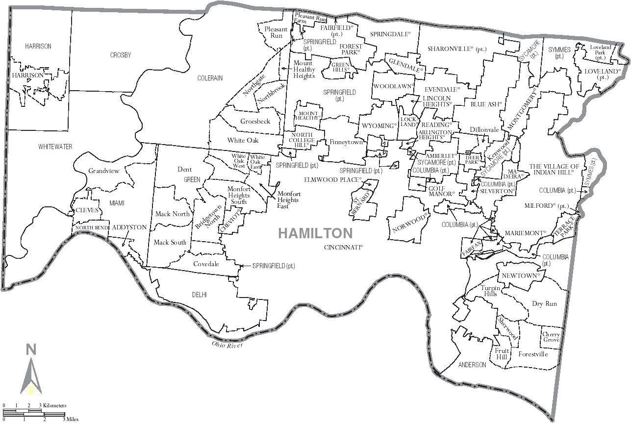
Note that it includes CDPs.
and here is my first draft at a route
Isn't Google Maps new feature of being able to auto drag and drop maps and directions cool! It's like they're listening right to me! This nearly eliminates the need for places like http://www.routebuilder.org and http://www.gmap-pedometer.com.
No comments:
Post a Comment