(Editor's note: This recap was written by Jim. I put in a few links and my a few comments - but everything funny was Jim's - hopefully he won't mind my editing)
The following report is done without extensive referencing of notes and, sadly for the readers, without much style or hyperbole. It's merely drawn from my meandering memories of the trip, which are spotted with delirium, checkered with short naps and stained with Black Bean Pueblo Pie.
I'll topline this by saying something I didn't think I would: this is an accomplishment of which I am proud.
Of course, ultimately the real achievement lies with Dan, for having meticulously planned the trip and having served as its impetus. I suppose the most credit I could take in good conscience is this: without my carving an extra couple of days out of my offseason work schedule, this trip might have become yet another one of Dan's elaborate plans that are ingenious and just might work but are destined to never happen. Like buying billboards and retiring soon after due to the prodigious income (Ed: Billboards are big moneymakers, for your information!). Or riding every subway line in New York City. And, yes, that old sentimental favorite, the EFS tour -- a plan to visit every major league stadium hatched by 16-year-olds without girlfriends and partially funded by the sale of Skittles. The list goes on and on.
In any case, I'm proud of it because it feels like we accomplished something. Here's why:
- To our knowledge, we finished something that has never been done before by anyone. Search the Internet for a comparable feat, and you'll just find a handful of people who are planning to visit all 88 of Ohio's counties in a year, or a decade or a lifetime. Most of the time, their goal dies halfway through. As near as we can tell we three are the only people alive or dead to visit all 88 of Ohio's counties in a 24-hour period (Ed: I'd be VERY surprised if anybody else has done it in 24 or less. Kind of a random feat to accomplish, you say? Maybe. But no one else can claim the same.
- It required meticulous planning. Again, this credit belongs almost solely to Dan except for when I acted as a second set of eyes to tighten up his route. I know that the route went through many iterations and permutations throughout the course of a year or more, and that stage, of course, was the most important. We had two 2" binders detailing each section of the route. Even when we encountered a closed road, we had enough maps so that we could determine an alternate route on the fly. I can't imagine how difficult this trip might have been without resources such as MapQuest, Google Maps, Google Earth and Routebuilder.org. It would have required local areas maps of all of the counties and a whole lot of photocopying. Even then, you would only have the ability to estimate distances. The tools available to us allowed Dan to accurately estimate our distances and our times. You'll find that those times and those distances were almost dead-on.
- We still could have failed. Despite all of the planning and all of the thought that went into the trip, it honestly wouldn't have taken much to rip the glory from our hands. Just one traffic jam or lane closure or car accident in front of us might have been enough to keep us from attaining our goal. That's not to mention speeding tickets or bad weather or a blown tire or colliding with one of the 876 sets of deer eyes we saw along the way. Dan does not agree, but I truly believe this: even knowing what we know now, I think if we tried this 10 more times, we would only succeed 5 times. A lot of things went our way on the trip, excepting a little fog, a broken credit card processor, one closed road and a couple of other poorly marked ones. A lot more things could have gone wrong, and that's one big reason why if someone else were to try this, success would be far from a guarantee. (Ed: The only thing I think that could sink us would be bad weather - rain/snow. I think with clear weather, we succeed 9 times out of 10.)
- The phantasm of failure makes success all the sweeter. Let's be honest; Dan's time estimates were blind guesses. Even throughout the trip, we found that we generally gained time over the estimate on the Interstates while we ceded ground on the country roads, especially after nightfall. But on the whole, the estimate was very good. It should be known that the estimate for this trip was 23 hours, 58 minutes. In other words, if all went according to plan, we'd cross the finish line with two minutes to spare. This also didn't factor in any breaks, even to fuel the vehicle. So to accomplish the task, we'd need to beat the estimates. Rolling into Preble County with less than 26 minutes to spare legitimized the difficulty of the task. If we had found that our estimates were flawed and we finished in 21 hours, the end result would not have included such a sense of triumph. If you finish this trip in 23 hours, 34 minutes and 34 seconds, you have to have problem-solving, guile, dedication and a collection of very heavy right feet.
Those are the reasons that this trip became a lot more than a cool way to spend a couple of days with two guys you've been friends with for 25 years. I know it sounds silly, but this is something difficult that we did. It might not rank on the top things to get checked off of my life's "to-do list," but nonetheless it was beyond a crazy thing to try and a story to tell.
Of course, there were plenty of good times to qualify this trip in that category as well. Referencing Dan's previous post, reciting the words "No can do" after you've been awake for the better part of 30 hours causes steering wheel-pounding hilarity.
We found out early on that small things might have the capacity to derail the successful completion of the trip. Jay's flight was delayed, meaning that we had to sacrifice some sleep on the front end. When we returned, Jeff turned on the X-Box, costing us more sleep. And then there was the rental vehicle.
We made a reservation for a compact car (a Dodge Caliber or similar), but true to most every rental car experience I have ever had, Thrifty Rent-a-Car didn't have the car we rented. They offered two options: a minivan with satellite radio or a minivan with satellite radio. It was a free "upgrade." And it was all they had. There was more room in the minivan than there would have been in the Dodge Caliber or similar, but there was distinct drawbacks too. It didn't get good gas mileage. The center of gravity was too high, causing us to slow down on treacherous country roads. And the big one: the last time I drove a minivan on an interstate highway, I rolled it over three times and landed it on the median while all of my possessions spread themselves out along the highway. (Ed: Under definitely suspicious circumstances)
I retold this story at the Thrifty rental counter to Dan, Jay and Jeff. We also joked that the minivan would hold some advantages, like having enough room for the midgets. This made one of the Thrifty workers erupt in laughter, and although we clearly had bad intentions for the minivan, they nonetheless inexplicably rented us the vehicle. Fools. We drove away in our minivan (which did NOT have satellite radio nor did it even pretend to have satellite radio).
The last laugh was on Thrifty Rent-a-Car, though. Two days later, we'd return the local-radio-only Town and Country with a broken arm rest, 1600 miles of wear, and an engine light glowing amber. All for $135 and change, including the insurance and tax. They should have given us the Dodge Caliber.
Or similar. Similar would have been just fine.
The Thursday morning drive to our starting location in Monroe County was lively. None of us were operating on a full measure of sleep to begin with, but it didn’t seem to matter. Debates crackled about Firehouse’s greatest hits and the namesake of Zanesville (Ed: Not Zane Grey). At a gas station in Noble County, three colons were emptied. A wife and two girlfriends were called. I bought some Sour Patch Kids for a quick boost and Jay bought his first bag of jerky. He would tear open three more bags of jerky before he met his mattress next.
At the Monroe county line, we all piled out. Rotating pictures of us in pairs were taken at the start line. No picture of all three of us exists from the trip, in part because the only on-lookers at the beginning of our trip were some very confused and discourteous looking cows. Little did they know that they sat in mud adjacent to three worthy claimants to the legacy left by de Gama, Cook, Balboa, Magellan, Coronado and others. I stared down one cow and wondered if she would hold such contempt for us if she only knew.
With the simultaneous blip from two digital watches at a bit before 11 a.m. Eastern Daylight Time, the trip began. A third watch was brought along to measure “pansy time,” which could simplistically be described at time used that was not figured into the pace. Missed turns and even fuel stops were counted as “pansy time,” simply because they weren’t on the timetable. We’ll discuss more about pansy time later.
One lesson learned very early in the trip is that minivans aren’t built for the twisting roads of Southeast Ohio. Now, perhaps if one of us had been a mom living in a suburban neighborhood, one of us an infant and another a child headed to soccer practice, the minivan would have been a perfect choice. In the rural, twisting outlays of Southeastern Ohio, though, the minivan did not perform like it was on rails. Many were the hills which we crested blindly, without specific knowledge of which way the road would turn on the other side. Many were the turns into which we careered at speeds where centripetal force wanted to carry us into a guardrail, along with our local-radio-only Town and Country and our maps and our Mini-Oreos. Many were the soft curves which forced the driver to become familiar with both lanes, lest he hit the brakes too often and cede valuable time.
On roads that bent to the left, one could take the turn a bit faster by first crossing into the left lane. On roads that bent to the right, the turn might well finish in the opposite lane. Either way, this strategy widens the arc of the turn. And both ways lead to high comedy.
Whenever the yellow line was crossed, it became apropos to yell out British-sounding phrases in a thick English accent. For instance, at the end of a turn when the Town and Country crossed into the oncoming lane, someone might yell out, “FISH AND CHIPS!” or “’ELLO, GOV-NUH!” or “PUT ON YOUR KNICKERS, WE’RE GOING TO A PUB!” because, as we all know, the English drive on the left side of the road, and they love pubs and fish and chips.
The trip was only three counties old when we encountered our first difficulty. On Ohio Highway 800, the twisting road ran smack into the back of an orange ODOT truck, placing orange cones on a freshly-painted white line. The truck was moving in concert with a truck ahead of it, which, with protruding nozzles on both sides, applied fresh paint to the road. A 2-foot sign on the back barked “DO NOT PASS,” and the meandering road with blind turns seconded the notion. About three minutes was all I could take of looking at the back of that orange ODOT truck. We sped past both trucks on a harrowing turn. The trip was back on track, and I idly wondered whether it would be okay to return the Town and Country to Thrifty with road paint misted on the side.
We discovered very early that a minute was going to be a big difference. If we were going to do this thing in time, it was going to be close.
Harrison. Tuscarawas. Coshocton. We bowled through the first hours of the trip, gaining a few minutes of advantage on the pace. As I noted above, the pace would have had us finish the trip in 23 hours and 58 minutes, not accounting for fuel stops (or ANY kind of stops). At 2 p.m., I crossed the van into Jefferson County and picked up the 12th domain of 88. It remained in Jefferson for 22 seconds and we were off again. Ironic to have a Town and Country inside of a county. Wrap your head around that one.
In any case, we were 23 minutes ahead of schedule and building a lead. We knew that we’d have to get ahead of schedule early because of a couple of factors:
- Nightfall would hit and last for 14 hours. We knew that we wouldn’t be able to make “British” turns under the veil of darkness.
- At some point, we’d have to let Dan drive. (Ed: Bite me)
When we hit the booming dual metropoli of Shanesville and Sugarcreek (combined population: 9,702), we discovered another reason that we’d need this cushion. School was letting out and we’d trail a schoolbus or two. We were also clogged behind (of all things) an ODOT truck, which slowly tooled by the antique malls of Tuscarawas County. If this was the traffic we’d hit in the sparsely populated Southeast, what did we expect to encounter in the truly metropolitan areas of the state?
It was also in Tuscarawas County that we encountered out first jaunt off of the pavement. Coated in dirt and gravel, Haas Road led us exactly where we wanted to go. I smiled. Now, this seemed like an adventure.
We learned interesting facts along the way about, for instance, the percentage of water coverage of each county. At my urging, Dan had printed the Wikipedia page for each county and brought a separate binder full of that information so that we could learn, for instance, what percentage of Carroll County’s residents were aged 65 or above (Ed: 14.20%). The astute macroeconomic minds that we are, we were appalled by the low median household incomes of Southeastern Ohio (Ed: Morgan County? $28K). No doubt Jay wondered how we might help. No doubt Dan wondered how he might buy up the entire area and use it as a springboard to world domination.
Before it got too late, Dan took the wheel. I believe it was on Ohio Highway 86 West at a red light (Ed: Actually it was on US 6, west of Chardon). We changed positions in the style of a “Chinese fire drill” at the traffic light, and when it changed to green before all the doors were closed, two seconds of pansy time were tacked on. The docile drivers of Geuaga County didn’t seem to mind. The Town and Country, however, was angry. It insisted, with a repeating and ear-splitting beep, that everyone in the front of the vehicle have their seatbelts fastened at all times. We wondered for the rest of the trip who was the fussy one: Town or Country. (Man, these jokes just don’t seem as funny now.) (Ed: But they were dang funny on the trip!)
On Interstate 71, the trip encountered another problem. We hadn’t planned very well for fuel stops. Although the Town and Country had a digital readout of “Miles ‘Til Empty,” we didn’t know exactly where we’d be when it neared zero or what gas stations would be around. So when the MTE display got to about 20, we determined that we’d pull off the interstate for gas. This takes a much longer time than pulling into a gas station, for instance, on a state highway. I figured the stop might take as long as five minutes.
We quickly located a shining beacon in the nighttime desert: the Goasis gas station. It was near the off-ramp and looked to have dozens of pumps. After some initial indecision, Dan pulled next to a pump and handed me the gas card. He and Jay bolted inside to use the Goasis restrooms. Meanwhile, I swiped Dan’s card and stared at the screen, which displayed “Authorizing Credit Card” for a solid three minutes. My mind called Dan’s credit into question. Four kids is a lot to buy toys for! And diapers! What must have happened to his credit score? After a prolonged and impatient wait, I pressed the button to talk to the attendant. She explained that their phone service was down and the outside credit card readers were not working. She said, “you can come inside and we can try this one.” Try? TRY?!?!?! Such incompetence! I didn’t have time to TRY anything! As I hung up the pump, Dan and Jay were trotting out to the van. “Perfect!” they yelled. But it was not perfect. Not a drop had been pumped. I dashed inside while rifling through my pocket for cash. I paid for $35 on the pump and dispensed the gas, while the pansy watch hummed a tune. With no time for proper etiquette, I transformed into Bo Duke. I jumped inside the van cannonball-style and into the back-row seat. SNAP! I’d jumped into the arm rest and cracked it. The floppy bar will no longer offer support to anyone sitting behind the passenger seat.
But at least I’d shut up that pansy watch, as it sneered at me from my right wrist.
By the time our tires met I-71 again, the pansy watch proudly displayed 10 minutes and 30 seconds. Admonishing the watch that this was just an isolated, fluke incident, I mashed its RESET button. This type of trifling was, hopefully, behind us.
With 29 counties in the taillights, the Town and Country’s headlights flashed on Knox County. With the left blinker on, we were about to turn onto Darlington Road, which would take us to Morrow County and on our way. But ODOT struck us a blow. Darlington Road was closed to through traffic, and we had to figure a way around it.
I have to say that this was probably my favorite part of the trip. Immediately, two binders were raised and the driver was on high alert. We problem-solved our way around Darlington Road (thanks, in no small part, to Dan’s maps), and we even caught a potentially catastrophic wrong turn before it took us too far off course. Pulling it past two dogs who chased us out of Knox, we got back on track. Little did the dogs know that we were only too happy to be in Morrow County. They could go back to defending their street all they wanted.
At some point, someone intoned “has that engine light always been on?” It was not good. The Town and Country had less than 8,000 miles on it! Why would the engine light be on unless it was dangerously close to systems failure? We decided to take our chances anyway.
Across the state we went, remaining just South of Lake Erie and Michigan as we forced Northwest Ohio into submission.
And there, in Fulton County, we were humbled to meet the King.
Ohio Highway 66, AKA “The King,” dances along the county boundaries of Northwest Ohio. We would visit seven counties with The King that would have otherwise taken great difficulty to reach. The King doesn’t stay exactly straight as he runs south. As we noted, The King likes to jog. That’s how he visits so many counties.
From Fulton, we followed The King to Henry, Williams, Defiance, Paulding, Putnam and Van Wert. As we drove east on US-30 toward Allen County, we gave three cheers for The King. Long may he live. (Ed: Hip, Hip, Hooray!)
Just after Wapakoneta, at around 11:30 p.m., I decided it might be a good time to catch a quick nap. Even though the late night fog was thickening, there were interstates and limited access highways ahead; not much to slow down the trip’s progress.
Just west of Franklin County (#54!), my head arose from the roll of paper towels it had been using as a pillow. We were slowing down. I couldn’t explain it until Jay said, matter-of-factly, “yep, we’re getting pulled over.”
The patrolman was prompt in getting out of his vehicle and was brief in his inspection through the side window. It was normal, apparently, to encounter a minivan with three 30-year-old men in it around midnight. That one passed out on the back seat? Ordinary. The ground is strewn with maps and papers? Typical. A large cooler is sitting in the middle of the van? Par for the course. Besides, what could that cooler possibly contain, other than Powerade Option and a 4-pack of Mountain Dew Amp?
Also, what if the patrolman had questioned Dan and me? Would it have been commonplace to find one person from Ohio, one from Alabama and one from Massachusetts driving at night in a minivan that didn’t contain at least one child going to soccer practice? This was no workaday situation. But it arouses this thought: what would it have taken to pique the suspicion of the patrolman? If I had been flanked by two Mexicans in the back seat, would he still have considered this a garden variety traffic stop? What if we weren’t really joking about those midgets? What then? (Ed: It really was surprising the lack of hassle we got there)
The patrolman smelled nothing suspicious and let us go with a warning. It’s a good thing we hadn’t dipped to heavily into the Black Bean Pueblo Pie, or we might have been looking at a full vehicle search.
I was done with trying to sleep. How could I, when we might face more unexpected challenges? Sure enough, less than an hour later, we did.
We were in Perry County as we neared the Muskingum County line. Dan barked out “take a left here!” And Jay’s response came back, “you mean through this garbage dump?” I was quickly reminded of a conversation Dan and I had a week prior – about roads being listed on the map that either didn’t exist or weren’t open to the public. Some roads led right up to nuclear power plants and armed guards.
Shortly thereafter, I harkened back to an earlier “Every Whatever” tour, and I remembered the disastrous failure it had become. In the late summer of 1993, we had planned to drive on every road in North Olmsted. The map showed a little-known road named Elston, which, we came to discover, was in the middle of a patch of forest. It doesn’t matter, we reasoned. After all, what part of WE HAVE TO DRIVE ON EVERY ROAD was less than crystal clear? It had to be official! We drove into the woods, only to stop at a log that cut through the path. When we tried to double back, the tires whirred in the mud. Well, four hours, two broken taillights, one severed brake line and two tons of mud later, we made it home, never having quite reached the elusive Elston Road.
It’s good to know that we’ve learned something in those 13 years since. With the same sense of bravado, we hit the dirt road which went around the trash dump and plunged into a patch of forest. We hit the road which, at least on the map, led us where we wanted to go. After all, what part of WE HAVE TO BE IN EVERY COUNTY was less than crystal clear? It had to be official!
In that patch of forest, at about 3 a.m., I clearly saw a flashlight beam searching around and I saw it wash over our vehicle. Clearly someone was trying to kill us. What’s more, the “roads,” if they could be called that, no longer had street sings. Clearly, we’d been lured into some sort of trap by ODOT or a similar foe. It was reminiscent of a colonial ambush scene. We were on a path in a valley in the forest, with slopes on either side. There was nowhere to run and hide if berserk ODOT workers rushed at us from both sides. Our flanks were exposed!
Luckily, after a few miles, we saw a road sign: Palmer Road. It wasn’t on the map.
We headed back through the gauntlet and I saw the flashlight again. Jay and Dan decided to try another way into Muskingum County, and I decided to call my brother. For somehow, even though my cell phone had been getting no reception in more developed areas, it got three bars’ worth at a trash dump near the Perry/Muskingum County line. With the help of MapQuest, Joe confirmed that Palmer Road lay in Muskingum County. “Turn it around!” I shouted. “We’ve been in Muskingum!”
Thus was county #61 brought under our control.
I stayed alert through Hocking and Athens and Morgan and Washington and Meigs in case I was needed. I also remained at the ready for Vinton and Jackson counties. But in Lawrence, I allowed myself to drift off again. Sure enough, 20 minutes later, we would encounter trouble.
The entrée to Gallia County from Lawrence County is at best sketchy and at worst downright shady. I awakened to find our Town and Country in a similar situation to the Muskingum County debacle, in the middle of a patch of forest. Dan and Jay were disagreeing on where we were. This was dire. I shuffled off my sleep and manned a binder.
We made not one, but two jaunts onto unmarked roads, hoping that we had made it into Gallia County (Ed: We had). It was one of the few counties that was not marked with a sign. By the time we got back on track and on the way to Scioto County, we’d fallen a few minutes behind schedule. The country roads leading us back through Lawrence County made us fall further. At our nadir, we were wanting for 9 minutes.
Whatever their sinister intentions to foil our trip, ODOT must be commended for its excellent demarcation of county boundaries. Except for when we entered on Elston-like roads, there was always a nice green sign to greet us. We were able to photograph most of them, and I figure those snapshots will find their way onto this blog soon. (Ed: Maybe if someone will get the pictures off his camera and email them to me?)
Whatever troubles Gallia presented, they were behind us. Jay had driven for 9 hours through the worst part of the night, and clearly Gallia had frayed his nerves. We were behind the pace and the fog was almost intolerable. Imagine driving for 9 hours in the darkness, with fog in front of you and two lights on in the van. Jay’s last act as driver was to slip into Ross County and pull a quick U-turn back into Pike. But he missed the turn and potentially set us back another minute (Ed: Pansy time!). What’s more, he’d had to poop for roughly four hours. When he pulled into a gas station off US-23, we discovered that he’d gained back the time he’d lost. And as I pumped gas, Jay and Dan went inside to poo down. But there was no time! Jay sacrificed his #2 for the good of our pace and hopped back in the car. It could wait another four hours. Jay is to be commended for his determination and his mental, optical and intestinal fortitude.
Negativity had dominated the previous hour, but optimism was burgeoning. Dawn was breaking. A limited access highway was ahead. And I was taking over at the wheel for the anchor leg of the trip.
Ohio 32 West provides a straight shot through five counties for 75 miles at a 65-MPH speed limit (Ed: Highland county? 13 seconds). Since I needed no navigation, it was suggested that both Dan and Jay sleep.
Jay was out and snoring within a minute. Dan slept only partially in Ross and Brown counties and all the way through Adams (Ed: The only county I entirely missed). It was a grand total of maybe 20 minutes. While both of them were incapacitated, I drove and snapped pictures of the county signs. Adams. Brown. Highland. Clermont. (Ed: You were definitely the king of picture taking)
Worry set in that I-275 around Cincinnati or I-71 just north of Cincinnati might be congested. It was 9 a.m. on a weekday, and folks might still be getting to work, tied up in a traffic jam. We found the roads clear, however, and we realized that we had leapt our last great hurdle. We were clear of Cincinnati and 23 minutes ahead of schedule. We tried to admonish ourselves to not get too excited. There were still countless things that could prevent successful completion of the trip. Only when we got 3 miles away (close enough to know that we could run there in time, if necessary) did the celebration begin.
We crossed into Preble County British-style, for effect, and soon after, piled out of the car to drench the ground with stored up urine.
23 hours, 34 minutes, 34 seconds. A new record. Something to be proud of.
Unfortunately, no “Entering Preble County” sign exists. One last middle finger from ODOT. (Ed: Word)
The two gas station stops we made immediately after completion was by far the trip’s longest. Jay bought bag #3 of beef jerky. We waited, with full colons, for someone to come out of a locked bathroom. They never did, and the clerk didn’t have a key. We moved on to the next one and befouled the bathroom at the Shell station.
On the way back to Columbus, we encountered something we really hadn’t the entire trip. Traffic. It was just a reminder of how the trip, had things been slightly different, could have easily failed.
Tuesday, November 21, 2006
Tuesday, November 14, 2006
Official EFC songs
I have a few recap posts in me that I'd like to get up here at some point. Also, I know Jay composed 4-5 blog posts that we can get up here. In the meantime though, let's talk some music. While we were out and about visiting all 88 Ohio counties, a poll was taken to determine the official trip song(s). Here are the Top 3:
#3 - Coward of the County, by Kenny Rogers. This was mostly sung to / about our friend Trampus, who wimped out on this journey. He was subsequently declared to be the "Coward of the counties". One other friend, Jeff, would have also been declared C of the C, due to his "have to work" mentality, but he got himself off the hook by providing a place to stay on Wednesday night as well as the purchase of acceptable amounts of snack rams, including cheese.
#2 - Washington, Washington by some unknown Internet guy. At the aforementioned Jeff's house on the aforementioned Wednesday night, Jim showed us this video. Note that this video has much more swearing than I would prefer. Nevertheless, QUITE funny. Anything that includes the line "He'll save the children, but not the British children", accompanied by a sketch of George Washington throwing a flaming British schoolhouse off of a cliff you know just HAS to be good! It was a tragedy that we were only in Washington County for 45 seconds or so. Of course, on the flip side, you never want to trespass in the home of someone who is 12 stories high and made of radiation...
Somewhere around 6 a.m., as we were approaching Hamilton County, and after reciting the Washington song for about the 300th time, we came up with a Hamilton, Hamilton parody. Here are the lyrics:
Hamilton, Hamilton...Killed by a bullet from Aaron Burr's gun.
Hamilton, Hamilton...He ain't on the twenty but he is on the ten.
Of course, after coming up with those 2 examples of lyrical genius, we were just about out of things that we knew about Alexander Hamilton. We tried to come up with something about his being a Whig, but could not come up with any rhyme better than "HIS POLITICS WERE BIG!", which is of course just stupid. As it turns out, it was just as well, since he wasn't a Whig anyways, but rather the founder of the Federalist Party.
#1 - I can't go for that (No can do) - Hall and Oates. With the amount of times on this trip where it was mentioned how George Washington once held his opponent's wife's hand in a jar of acid, it seems odd that it could be beaten out for the #1 song, but I can't go for that was voted #1 by a unanimous vote.
Some time early in the trip (or maybe even on the drive out to the starting spot), I mentioned that I had seen on VH1 where they counted down the Top 100 songs of the 80s, and I can't go for that made it in at #6. We all agreed that this was much too high, and it kind of just snowballed from there.
Example usage:
Jim: "Man there's an ODOT truck painting lines on the road up ahead"
Dan: "I can't go for that"
Jay: "No can do"
Just imagine similar scenes, repeated 5-600 times over a 24 hour period. Of course, there was also the flip side
Jay: "We just missed a train crossing!"
Jim: "I can go for that"
Dan: "Yes can do"
All in all, good times! I hope you have enjoyed this musical recap.
Friday, November 10, 2006
County proof
Dan, checking in with another brief note here. I will endeavor to post a few more detailed posts over the next few days, after I sleep for about 200 hours. Also, Jay wrote a few blog posts that I'm sure he will post here sometime.
But I wanted to clear the air about a few counties. We did get a bunch of pictures of county signs, though not all of them. It was quickly determined that Jim was the world's foremost authority on county line sign photography, and he did a stellar job capturing many of the signs. Jay and I, however, are complete incompetents in that regard.
Plus there were a few county borders where there no signs. Overall, I was very impressed with the sign marking, especially on any state/US routes. And for most of the time even if there was no sign, it was obvious where we were from our maps and the road signs we could see. But there were a couple of times where our exact position was not clear.
- Gallia County. The plan for Gallia county was to come south on OH 93 from Jackson, OH. (If you want to follow along, get out the map website of your choice and start at Jackson, OH. OH 93 for about 15 miles or so, through Oak Hill and into Lawrence county. Once in Lawrence county, turn on CR 38 (Blackfork-Peniel Road). Unfortunately, we missed that road due to the darkness (it was about 4 a.m. at this point) and turned on to CR 39 (the next road south). We followed that road, if it can be called a road, for probably close to 2 miles or so to a T-intersection, but still we weren't sure if we had made it into Gallia. The problem was that it was hard to tell whether we had gone east on "Dry Ridge Rd" or south on "Township Road 152". If the former, we definitely made it into Gallia, if the latter, than we didn't. We ended up getting back to OH 93 and taking CR 38 for a mile or two just to be sure. But in looking at Topozone, it shows Union Baptist church on CR 39. We definitely went around the left (north) of that church and then went on for about 2 miles, so I'm making the call as definitely Gallia.
- The other close call was a few hours earlier, in Muskingum county. After getting off I-70 at Exit 141 near Brownsville, OH we went south on OH 668. The route said to turn left (east) on Bowser Road and take that into Muskingum. Again, this road was questionable in quality. Eventually we got to an intersection listed as "Palmer Road" and "Mt Perry Rd". Neither of those were on the maps that we had, so we backed out and were going to try something else (N on 668 to US 40 East to Muskingum). We called Jim's brother, working the night shift, and he was able to verify that Bowser Road turned into Palmer road once in Muskingum, so we were able to get back on our way with only a minimum of "pansy time".
- There were 2 other areas (in Richland and in Tuscarawas counties) where there were questionable road qualities, but neither of those had any possible county counting affect
ODOT: Friend or foe?
Well, as mentioned earlier, it is finished, and with a world record time. First of all, I would just like to say thank you to all of our guest correspondents - it was very fun to be able to call in progress reports and such, and I'm glad that we were able to keep our legions of adoring fans updated.
A recurring theme of our journey was the many attempts of the Ohio Department of Transportation (ODOT) to thwart this trip. Some of these, such as the paint crew and the lollygagging in the Shanesville-Sugar Creek twin cities metroplex, have already been mentioned.
When we mentioned the near-miss train to Jim's brother, he surmised that somewhere there was a high-ranking ODOT employee cursing and saying "The train was late!" As we came westbound on I-70 for the final stretch, there was an ODOT work crew with the Interstate shut down....eastbound! Obviously someone had given them incorrect information on our route.
Perhaps my favorite example of ODOT tampering was in I believe Medina county. Right after we got off the highway, we were stopped at a stoplight for what seemed like FOREVER. As we were all commenting on how long this light was, we looked over, and there was an ODOT employee messing with the signal junction box!
At one point, it was postulated that perhaps ODOT was trying to HELP us, and there were other forces trying to stop us, but ODOT was doing its best to aid us. That was quickly shot down. We thought maybe that there was a secret band of ex-ODOT employees trying to stop the Department from executing its nefarious plan.
In other news, it was confirmed via Topozone that we were definitely in Gallia county. So that's good. (Not that I would ever admit to only reaching 87 counties :-) ).
IT IS FINISHED!!
I am on the phone right now with Dan, he said they have just finished the amazing race. Oh wait, that's something else. They have just finished the amazing EFC race. It took 23 hours 34 minutes and 34 seconds. The world record has been set. No one has ever done this before and who knows if it will ever be done again!
And the Award for Best Husband goes to Dan Miller
I just want to say how proud I am of Dan for making this EFC trip a reality. I must admit when he first presented the idea of visiting all 88 counties in Ohio, in one trip, in less than 24 hours I thought it was pretty silly. Ok, more like down right weird. I know Dan loves maps and planning the shortest routes to various places. Even when he made plans and set dates, I kind of thought he wouldn't actually do it. But I am very impressed at how he made this happen...with the help of his friends, of course. I love to see him set goals and make them come true. Being married to Dan I get to witness first hand his grab bag of off the wall ideas. But what an awesome adventure! I'll be cheering for you when you get home. You're the man now dog!
Taking a Long Drive
I was just checking out the forecast for Cincinnati, mostly because I live here, but also because the EFC guys will be heading through here very soon. We have a beautiful day ahead, partly cloudy with a high of 72. Lovely!! In fact, just below the 36 hour forecast, where it says Today, it suggests: Plan a Scenic Drive. Gee, what a lovely idea. But what I want to know is did anyone drive through any covered bridges in the last 24 hours. Hmm?
Morning hours
The folk are on schedule. The county count at this point is 72. Currently in Pike county. The night was tiring and there was lots of fog. They lost time because the road to Gallia county was not very well marked, so they had to go back to make sure they had actually gone into Gallia. No Cheating!! I think the boys are losing their focus due to lack of sleep. No one sounded very chipper.
Controversy!
According to a key operative from my Muskingum-based army of superintelligent deer, the red van narrowly missed missing Muskingum county at about 2:45 tonight. Not perfect grammar, I know, but pretty good for a deer. Clarification was required on the county status of a Palmer Road, and assistance was called upon in the form of a littermate of one of the travellers. Deer do not differentiate between brothers and sisters, they just call them all littermates.
Due to his hyperdeveloped sense of smell, the deer operative was able to confirm that food supplies are more than adequate to last the scant few hours remaining in the journey. Of course, deer routinely eat, like, all of their food so that a bunch of them die. Not my superintelligent army of deer, of course. They are fed a diet of the finest genetically engineered hay from the slopes of one of three hills in southern Peru, grown by a family of haygrowers that has done nothing but grow hay since Francisco Pizarro was in diapers. They're the best. As a training tool and a reward for supplying valuable information, the deer are sometimes allowed a taste of the fabled "salt lick of 7 kings." I know one deer who's slated for some lick time once he's off duty tonight! Anyway, my point is that I'm not sure I trust a deer's opinion on the adequacy of food supplies.
Due to his hyperdeveloped sense of smell, the deer operative was able to confirm that food supplies are more than adequate to last the scant few hours remaining in the journey. Of course, deer routinely eat, like, all of their food so that a bunch of them die. Not my superintelligent army of deer, of course. They are fed a diet of the finest genetically engineered hay from the slopes of one of three hills in southern Peru, grown by a family of haygrowers that has done nothing but grow hay since Francisco Pizarro was in diapers. They're the best. As a training tool and a reward for supplying valuable information, the deer are sometimes allowed a taste of the fabled "salt lick of 7 kings." I know one deer who's slated for some lick time once he's off duty tonight! Anyway, my point is that I'm not sure I trust a deer's opinion on the adequacy of food supplies.
Serenade
Yeah
Can you feel it baby
I can too
Ooh
Come on swing it
C-C-Come on swing it
Ooh
Come on swing it
C-C-Come on swing it
1-2-3 - Now we come to the pay off
It's such a good vibration
It's such a sweet sensation
It's such a good vibration
It's such a sweet sensation
Yo! It's about that time
To bring forth the rhythm and the rhyme
I'm a get mine so get yours
I wanna see sweat comin' out your pores
On the house tip is how I'm swingin' this
Strictly Hip-Hop boy, I ain't singin' this
Bringing this to the entire nation
Black, white, red, brown
Feel the vibration
Come on come on
Feel it feel it
Feel the vibration
It's such a good vibration
It's such a sweet sensation
It's such a good vibration
It's such a sweet sensation
Vibrations good like Sunkist
Many wanna know who done this
Marky Mark and I'm here to move you
Rhymes will groove you
And I'm here to prove to you
That we can party on the positive side
And pump positive vibes
So come along for the ride
Making you feel the rhythm is my occupation
So feel the vibration
Come on come on
Feel it feel it
Feel the vibration
It's such a good vibration
It's such a sweet sensation
It's such a good vibration
It's such a sweet sensation
Donnie D break it down
Donnie D's on the back up
Drug free, so put the crack up
No need for speed
I'm the anti D-R-U-G-G-I-E my
Body is healthy
My rhymes make me wealthy
And the Funky Bunch helps me
To bring you a show with no intoxication
Come on feel the vibration
Yeah
Can you feel it baby
I can too
It's such a good vibration
It's such a sweet sensation
It's such a good vibration
It's such a sweet sensation
Now the time has come for you to get up
The rest had you fed up but Yo, I won't let up
On the rhythm and rhyme that's designed to
Make your behind move to what I'm inclined to
Pure Hip Hop, no sell out
If you ain't in it to win it
Then get the hell out
I command you to dance
I wanna see motivation
Come on now feel the vibration
It's such a good vibration
Come on come on come on
It's such a sweet sensation
Feel it feel it
It's such a good vibration
It's such a sweet sensation
It's such a good vibration
It's such a sweet sensation
It's such a good vibration
Come on come on come on
It's such a sweet sensation
Feel it feel it
It's such a good vibration
It's such a sweet sensation
It's such a good vibration
It's such a sweet sensation
Can you feel it baby
I can too
Ooh
Come on swing it
C-C-Come on swing it
Ooh
Come on swing it
C-C-Come on swing it
1-2-3 - Now we come to the pay off
It's such a good vibration
It's such a sweet sensation
It's such a good vibration
It's such a sweet sensation
Yo! It's about that time
To bring forth the rhythm and the rhyme
I'm a get mine so get yours
I wanna see sweat comin' out your pores
On the house tip is how I'm swingin' this
Strictly Hip-Hop boy, I ain't singin' this
Bringing this to the entire nation
Black, white, red, brown
Feel the vibration
Come on come on
Feel it feel it
Feel the vibration
It's such a good vibration
It's such a sweet sensation
It's such a good vibration
It's such a sweet sensation
Vibrations good like Sunkist
Many wanna know who done this
Marky Mark and I'm here to move you
Rhymes will groove you
And I'm here to prove to you
That we can party on the positive side
And pump positive vibes
So come along for the ride
Making you feel the rhythm is my occupation
So feel the vibration
Come on come on
Feel it feel it
Feel the vibration
It's such a good vibration
It's such a sweet sensation
It's such a good vibration
It's such a sweet sensation
Donnie D break it down
Donnie D's on the back up
Drug free, so put the crack up
No need for speed
I'm the anti D-R-U-G-G-I-E my
Body is healthy
My rhymes make me wealthy
And the Funky Bunch helps me
To bring you a show with no intoxication
Come on feel the vibration
Yeah
Can you feel it baby
I can too
It's such a good vibration
It's such a sweet sensation
It's such a good vibration
It's such a sweet sensation
Now the time has come for you to get up
The rest had you fed up but Yo, I won't let up
On the rhythm and rhyme that's designed to
Make your behind move to what I'm inclined to
Pure Hip Hop, no sell out
If you ain't in it to win it
Then get the hell out
I command you to dance
I wanna see motivation
Come on now feel the vibration
It's such a good vibration
Come on come on come on
It's such a sweet sensation
Feel it feel it
It's such a good vibration
It's such a sweet sensation
It's such a good vibration
It's such a sweet sensation
It's such a good vibration
Come on come on come on
It's such a sweet sensation
Feel it feel it
It's such a good vibration
It's such a sweet sensation
It's such a good vibration
It's such a sweet sensation
Grave news
According to the microscopic GPS unit planted within a carefully machined US nickel received by Dan in change from a 7-11 when he purchased a 20 oz. Dr. Pepper, our intrepid travellers are currently in Franklin county and have notched 56 out of 88 counties. They are 42 minutes ahead of schedule and have travelled 799.4 miles.
That's the good news. The bad news is, my OHP mole has reported through his Morse Code-transmitting wristwatch that a vehicle matching the description of that being used by our heroes (his exact words: a red van) has been detained on a trumped-up charge of exceeding the speed limit somewhere near Columbus. Of course, no ticket was issued because that would create a paper trail. Their motives are far more sinister than to cost Jay $75 and 2 points on his license.
That's the good news. The bad news is, my OHP mole has reported through his Morse Code-transmitting wristwatch that a vehicle matching the description of that being used by our heroes (his exact words: a red van) has been detained on a trumped-up charge of exceeding the speed limit somewhere near Columbus. Of course, no ticket was issued because that would create a paper trail. Their motives are far more sinister than to cost Jay $75 and 2 points on his license.
They said it couldn't be done
For years the ODOT intelligentsia has been saying it can't be done. Don't be fooled into thinking they will let it be accomplished so easily. The "near miss" train was just the first salvo in an incipient barrage of semi-governmental transportation-related manacles. I am posting here under this clever psuedonym not out of timidity, but because by disguising my identity I may live long enough to help save your journey, and perhaps your lives (everyone that knows me knows I think Mark Wahlburg is a douche, as a matter of course I introduce myself with that caveat).
I apologize for the neccesary vaguness of my advice to you here. If I was more specific, my identity would become obvious to any agent of the Deep Blue Cabal or Strike Force Zulu. I offer this:
1. Beware any motorcyclists with flowing golden manes.
2. Avoid looking any moustachioed men in the eye.
3. That is not a cow.
Godspeed, gentlemen.
p.s. Wahlburg 4lyfe
Midnight: Desert correspondent signing off
As we near the blackout period I can't help but draw the analogy of astronauts passing to the dark side of the moon. Dan, the lifter of spirits, wanted me to tell everyone, "just because there are no updates... we probably haven't died or anything." Atta boy, Dan.
One of the rental van's many features is a digital readout showing how many miles to empty. When it reaches "0" you can still make it a few more miles, though. I'm pretty sure you've guessed why we know that.
As I was on the phone with the boys, the van and its occupants passed into Shelby county to bring the ccc to an even 50! Jay is driving and is feeling good, predicting that he can take them all the way to the next gas stop at dawn. I knew everything was ok based on overhearing,
"Ok, Jay, we're getting off here..."
"Right here?"
"Well, not RIGHT here... at the exit."
Yes, things are under control.
Thursday, November 09, 2006
My last update this evening...the 1/2way point.
Here's the latest information:
34 minutes ahead of schedule.
640 miles into the trip.
47 counties.
12 hours.
1 engine light is on. uh-oh.
One incoherent ramble:
"very much Enjoyed running with the king of roads (The Turnpike),
the king likes to jog, but that's ok because that's how gets to so many counties.
followed him to seven counties...as we bid farewell, we gave him three cheers.
Hooray for the king."
It's a quarter to 10:00, still going strong
The boys are now in Williams County bringing the ccc to... wait for it... 40! Darn close to that psychological 50% mark. They're in the Northwest corner of our fair state heading South towards Columbus which they hope to reach at about 1:00 am, 25 minutes ahead of schedule. It's the wee hours o' the mornin' that could spell trouble, but the driver rotation has been working like it's supposed to with Dan tapping out a few moments ago.
And just to get things factually correct (remember what happened to Dan Rather?) it turns out that there WAS indeed cheese on the sandwiches after all. I'm glad that's been cleared up.
P.S. I'm predicting that EFC #1 will eventually be known as "the great Black Bean Pueblo Pie debacle of 2006." What were you guys thinking??
It is now 8:28 pm
All three guys are talking on their cell phones to their various fans, right now.
The EFC crew has a nation wide syndicate of reporters standing by. (Me being one of them.) They are just about to cross their 35th county, Ottawa. They just cracked into the Black Bean Pueblo Pie. Dan hasn't had any yet. That's all folks.
The EFC crew has a nation wide syndicate of reporters standing by. (Me being one of them.) They are just about to cross their 35th county, Ottawa. They just cracked into the Black Bean Pueblo Pie. Dan hasn't had any yet. That's all folks.
7:00 The count is...
Current county count: 29!
A slight problem in Richland with Darlington Road being closed to through traffic, but our intrepid travelers brought area maps (maps on a road trip... note to self) which allowed them to lose only 3-5 minutes on a detour. Still 9 minutes ahead of schedule!
A good omen: immediately after going over a train crossing our boys saw the "train approaching" lights start to flash in the rear view mirror. A bad omen: the rental van has been chased by two dogs so far. Hounds of Hell? No, let's assume they were Pooches of Positivity.
The smell in the car was reported to be surprisingly fresh, due in no small part to the group decision to save the Black Bean Pueblo Pie for later in the trip. Good call.
Note for next year: MapQuest doesn't tell you which roads are gravel.
6:00 and all's well
Another update from Dan and the boys!
[Technical note - Dan wanted me to mention that the Blog is stamping entries with Pacific time. EST = PST + 3 for the algebraically inclined. ]
- The good news: Jim is making some delicious turkey and ham sandwiches.
- The bad news: no cheese
- The good news: The Goasis off I-71 has lovely bathrooms
- The bad news: The Goasis off I-71 has non-functional credit card readers, adding 5 minutes of pansy time for payment by cash
- The good news: 16 minutes ahead of schedule!
- The bad news: night driving time is approaching... could be a slowdown
[Technical note - Dan wanted me to mention that the Blog is stamping entries with Pacific time. EST = PST + 3 for the algebraically inclined. ]
Update time from the Wife
I'm currently on the phone with Dan for an update. I'm going to try to tell you what he is saying: They just got on interstate 80. They are about to head into their 14th county, Trumbull. 3 hours 47 minutes so far in the trip. Dan says they are about 28 minutes ahead of schedule. Dan made a wrong turn which cost the team 36 seconds. Jim missed the turn off for Ohio 164, which lost them 20 seconds.
No one hurt, no one dead. All mini Oreos gone.
No one hurt, no one dead. All mini Oreos gone.
And so it continues...
Desert correspondent Doug Bloebaum here reporting from Phoenix, Arizona where it's 70 degrees on the dot at the moment. But enough about me and the perfect weather... just got off the phone with Team #1 in EFC #1 who relayed the following info:
- The current county count (ccc) is now at 8
- The team is 12 minutes ahead of schedule (go figure, they had a schedule)
- ODOT is clearly trying to thwart the inaugural EFC running
- a paint crew on OH 800 with "do not pass" signs tried the old rolling road block trick. Fortunately the team knew that "do not pass" "do not apply" during emergencies. And following behind trucks spewing dangerous paint fumes is certainly an emergency.
- In the Shanesville/Sugarcreek metroplex the team again found themselves trailing behind a lallygagging ODOT driver. I can only imagine that fists were shaken and angry words were shouted. Probably not, but it adds to the dramatic tension, don't you think?
2:00 Status Call
The boys are doing well, and creating a few inside jokes on the way...
As of 2:00 (about 4 hours into the trip), they are 23 minutes ahead of schedule, and have already gotten through 12 of the 88 counties. Their pansy time (the time they missed a turn, had to stop for gas, or any other "non-progress" time) has been limited to one minute.
So here's the chart of progress:
Total Time: 4 hours
Time Ahead: 23 minutes
Pansy Time: 1 minutes
I would expect several more updates throughout the evening.
Also,
Trampus Smerk has been named Coward of the Counties.
And so it begins...
The boys have arrived in the "Monroe," as of 10:45 this morning. The trip should be beginning in the next few minutes.
Highlights of the trip from Franklin County to Monroe county:
Highlights of the trip from Franklin County to Monroe county:
- A lively debate about the hit singles by Firehouse.
- An argument over the namesake of Zanesville. Turns out it was not Zane Grey, but rather Ebenezer Zane, Grey's great-great grand-uncle.
Thursday morning update
Dr. Bohland's flight was delayed (twice) but eventually nancy-boy manned up and made it to the airport. One convenient part about the delays was that I got to watch Lost before going to pick him up. One inconvenient part about the delays was the fact that it was much later than I would have liked before I slept.
I slept fine in my girlie-bed. One thing I would have liked would have been to bring my cell phone or watch or something so I'd know what time it was in the morning. I ended up waking up at 7 a.m.
Currently Jay is showering and after that we are ready to hit the road.
Annoyance #1: I left my bag (containing my camera) either in my car at the airport parking or at home.
Annoyance #2: Thrifty did not have any rental cars of the type that we reserved. Now, I don't want to get all Seinfeld on everyone, but that does seem the whole point of the reservation. In any case, the only thing that they had was a minivan. Negative: lower gas mileage. Positive: bigger tank. Also more room (of course). We shall see how it works out. I'd take a picture but umm my camera is not here. So you'll just have to go with the fact that it's red.
No sleep til Preble (or something)
Wednesday, November 08, 2006
EFC weather
Just checked the weather, and things are looking good - no rain or other such unpleasantries in the forecast for tomorrow or Friday
NO! SLEEP! 'TIL PREBLE!
Well we hit our first snag in the competition. International superstar and Wikipedia page having rock star Jim Tocco did not drive up from Alabama last night. He will be leaving some time today and driving up. Once he gets here we will both drive up to Columbus.
This shouldn't affect any route details, though it does mean that the beautiful 6.2 mile running route I created for him through the suburban streets will go to waste.
Here's the route.
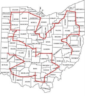
This is only a crude representation, but yes, these lines do represent actual roads that we have. The actual route has been done to much more detail, but it shall remain secret, at least for now. I just know all million of my readers are DYING to find out the exact route so they can visit all 88 counties before me. NOT GOING TO HAPPEN! :-)
I will post more either later today or tomorrow morning before we leave.
Tuesday, November 07, 2006
EFC Roster
Maybe it's time to give some more updates on EFC. Plans are still active - we'll be starting this thing on Thursday. I'd like to give a major shoutout to my wife, who is being very supportive of me in this crazy adventure. I know that being by herself with 4 kids for a few days is not her idea of fun, but she knows how important this is to me and is standing behind me 100%.
Anyway - the people that are going:
Me - Dan Miller - resident crazy map person from Cincinnati, Ohio and founder of this blog. Sometimes I look at myself and wonder if I missed my calling as an urban planner of some sort.
Jim Tocco - all around famous rock star from Montgomery, Alabama. Actually he is not a rock star but is in fact a minor league baseball broadcaster for the Montgomery Biscuits. But you can see why I would call him a rock star, considering how the man has his own Wikipedia page.
DOCTOR Jay Bohland - from Boston, Mass. The man has literally been in school non-stop for the past 25 years. Nobody is really quite sure what he did his dissertation on. It was titled "Neuroimaging and Computational Modeling of Syllable Sequence Production" so.... yeah.
Honorary member who was not able to man up (nancy) but is still providing us with a place to stay beforehand as well as various snack and drink ramifications - Jeff Blankenburg of Columbus, OH. I have only been to his house once, and what I remember most is that it was advertised as "2 stoplights" from I-71, and while that was in fact true, what was not mentioned was that these 2 stoplights covered a distance of like 6 miles.
I will try and post more as we get closer to kickoff.
Friday, November 03, 2006
EFOHC preparation
Well the 88 Ohio County trip is nearly upon us. This time next week, we should be somewhere either near or past the finish line, over in Preble County.
Plane tickets have been purchased, rental cars are being rented, and routes are being finalized. I will continue to make posts as we get closer to the date.
Anybody that I haven't talked to already that is interested in being a guest contributor (i.e. receiving phone updates from us while we're on the road and blogging them in) let me know
Sunday, October 29, 2006
2006 Tour de Madeira--P J's take
At Dan’s behest I am adding my thoughts on the 2006 Tour de Madeira. I won’t pretend to write with the same eloquence as Dan, but I shall certainly do my best!
As one of the co-riders in what was originally a bi-bike event I have to confess that I was primarily just “tagging along.” I don’t know
Our original date for the TdM was to be Saturday 10/28/2006 and we had each planned on biking training routes each weekend previous in order to be ready physically for what the streets of
[I would be remiss here if I didn’t add a quick positive note about my wife, if only because I know she’ll eventually read this and I’ll be in trouble if I don’t come clean: she was absolutely one hundred percent behind me doing the TdM. It wasn’t so much, “You should totally bike fifty miles at once! Think of the accomplishment! Think of the glory!” as, “Do whatever you want. It’s your body…” but she was incredibly supportive from the very beginning. I couldn’t have asked for a better support network.]
The first ten miles were difficult, if only because that’s where I had to come to terms with the fact that we were going to be on the bikes for a long time. This is also when we had the incident of trying to repeat
You’re probably thinking right now, “A cul-de-sac in Madeira? What a novel idea!” I personally wouldn’t use the word “novel” since about 123% of the community is made of cul-de-sacs! This I now know from personal experience…
The second 20 miles were the hardest for me, because that’s when I got to carry the pack. We had one between the two of us with provisions supplied through the generous donations of our primary sponsor, the Miller General Store. This was early enough that we still had plenty of liquid for the entire route and it proved to be heavier than I expected. Mile 11 gave me an instant appreciation for the work that Dan had been doing during the first 10 miles while I rode in absolute oblivion. After mile 20, though, the pack became significantly lighter as we went.
The miles after that kind of blurred together into one increasingly sharp pain in the rear end, no metaphor intended (although the pun, of course, is). With each subsequent break as Dan would check his notes I would wait, anxiously dreading: “Uhhhh, I forgot this one street back about 15 miles ago…” But just like when you’re playing basketball and you sometimes have the convenience of “the guy” who always remembers the score no matter how long you’ve been playing (which definitely comes in handy and prevents a lot of, “Let’s just say it’s tied…”), Dan consistently kept us on track with very few exceptions, and those being so minor as to be almost negligible. (Coincidentally, Dan is also “that guy” for us while we’re playing basketball…) The hardest thing of the entire experience for me was just being on the bike that long.
One quick note about the equipment we used: it may seem superfluous that I had over twice as many gears on my bike as Dan, but in my defense I ended up using every single one of them—there’s nothing like click-click-clicking your way to the very summit of a hill at mile 47, even if you are only going 0.5 miles per hour!
In review I have to say the TdM06 was a lot of fun, and definitely worth doing. I would encourage sponsors and riders worldwide to capitalize on this once-a-year opportunity and sign up now before it becomes so mainstream as to mean little or nothing. Plus the extra fame and accolades that accompany being involved in the critical formative years definitely merit the initial investment. It’s too late to have been there for the original tour, but there is still currently room for TdM07!
Thursday, October 26, 2006
Tour de Madeira ground rules
So let's talk some ground-rules of the Tour de Madeira. PJ and I have thrown down the gauntlet (5:43:33) for anybody who would like to beat it. And I'm definitely planning a TdeM 2007. I welcome anybody that would want to try and beat our time. I think it would probably be pretty easy for someone to break the time, but in any case, I thought it seemed appropriate to write up the "official" ground rules for the Tour de Madeira.
Obviously the final result says that you have to visit every street in Madeira, but that's just an overview. It could be used for any of these sorts of "Tours". But Madeira has some unique quirks that deserve clarification. As we found out on the actual Tour, there's always the fun game of "Is this a road, or is this somebody's driveway?" So here's a first stab at some "official" rules.
1. The full length of every street in Madeira must be visited, but you are allowed to go outside of Madeira if you want. Official time is from start to finish, and includes any break or rest time. You are allowed to bike or walk on each street. You may travel on the sidewalk if it is convenient, but travelling on the sidewalk does not count towards completing the route. Except where mentioned below, travelling through any part of an intersection between two streets counts as visiting the entire intersection.
2. Rather than listing off every street, I will list out the various border streets and special cases. Where a specific side of the road is mentioned, the route must include riding / walking on that (Madeira) side of the street. Where the city border does not occur at an intersection of two streets, you must ride / walk past the Madeira city sign posted on that road before turning around. Any streets within these borders that are not specifically excluded must be visited
Any comments / requests for clarifications / updates?
Obviously the final result says that you have to visit every street in Madeira, but that's just an overview. It could be used for any of these sorts of "Tours". But Madeira has some unique quirks that deserve clarification. As we found out on the actual Tour, there's always the fun game of "Is this a road, or is this somebody's driveway?" So here's a first stab at some "official" rules.
1. The full length of every street in Madeira must be visited, but you are allowed to go outside of Madeira if you want. Official time is from start to finish, and includes any break or rest time. You are allowed to bike or walk on each street. You may travel on the sidewalk if it is convenient, but travelling on the sidewalk does not count towards completing the route. Except where mentioned below, travelling through any part of an intersection between two streets counts as visiting the entire intersection.
2. Rather than listing off every street, I will list out the various border streets and special cases. Where a specific side of the road is mentioned, the route must include riding / walking on that (Madeira) side of the street. Where the city border does not occur at an intersection of two streets, you must ride / walk past the Madeira city sign posted on that road before turning around. Any streets within these borders that are not specifically excluded must be visited
- Montgomery Road (from Hosbrook to Galbraith - SE side)
- Galbraith Road (from Montgomery to east of Miami - south side)
- Miami road (north of Galbraith - west side)
- Camargo road (both sides - from west of Blome to Madisonville)
- Shawnee Run road (from east of Madeira Hills Dr - north side)
- Kenwood Road (from south of Kenwood Hills to Euclid - both sides)
- Euclid Avenue (from Ken Arbre to Hosbrook - south side; east of Hosbrook - both sides)
- Ken Arbre Avenue (from Euclid to Stewart - south side)
- Stewart Avenue (from Woodsway Dr to Ken Arbre - east side)
- Goff Terrace - From Miami to the Ferrari's parking lot
- Railroad Ave - From Miami past Center and into the first parking lot (7805 and 7809 Railroad)
- Dones Ave - From Camargo east of Marvin to where it splits into 2 driveways (going east to 7845 and south to 7825)
- Marvin Ave - From Dones to Sellman Park; no need to go past the Parking Lot
- Iuka Ave and Osceola Ave - at the south ends of both of these streets, there are triangular "median" type structures. You must travel around all three sides.
- Paisley Lane - You must go around the corner until the road dead ends into the driveway for 6680 Paisley
- May St - You must go all the way to 6600 and 6609
- Any of the streets of the mobile home park on Dawson Road
- Greylock Drive
- Any "named" streets on the campuses of any of the schools
- Shawnee Pines Drive
- Dot Ave
- Miami Road south of Shawnee Run road
- "Extended" driveways, such as 6873-6929 Fox Hill Lane
- The path through Sellman Park to Fox Chase Lane
- The narrow separate pedestrian walkway at the south end of Rita Avenue. You still have to travel all of Rita, but you do not have to especially go through this walkway as you do with the medians on Iuka and Osceola
Any comments / requests for clarifications / updates?
EFC update
Okay folks. We are definitely on for EFC on November 9th. There are 3 of us going, and it's a definite. Plane tickets have been bought. The tentative plan will be to meet up in Columbus on the evening of the 9th, and then set off early Thursday morning, finishing Friday morning.
Certainly further details as events warrant. Though I do have a few other Tour de Madeira posts left in me
Certainly further details as events warrant. Though I do have a few other Tour de Madeira posts left in me
Monday, October 23, 2006
Tour de Madeira 2006 report
Yes, folks, the 1st (annual?) Tour de Madeira has been completed, and the results are a resounding success!! The 2006 version only had 2 riders, but it was intentionally kept to a low number. That way, in 20 years when this is an international event, its humble beginnings will only look that much cooler.
Speaking of cooler, the weather that we had on Saturday was beautiful - just about perfect biking weather. Actually, up until the last hour or so, I'd say it was perfect weather. About 55 degrees, not much of a wind, mostly sunny. At the end, it got a little cooler though. The last hill coming down Camargo was a little cold. It was downhill and with the wind from the speed, my hands got pretty numb.
We did pretty much use the routes that I had mentioned before (Part 1 and Part 2), with a few exceptions.
1. Coming up Kenwood after having made the wraparound in Windridge / Whetsel, I led us back down Coachlite Way. After about 200 feet, PJ asked "Haven't we been down this road before?" In fact we had. So we turned around and continued up to Kenwood and turned on Lakota as part of the route.
2. After having come up Camargo from Shawnee Run, we followed the wraparound through Dones / Naomi / Marvin. First of all, we stopped briefly at Sellman Park for a "potty emergency". Then, after having come out on Miami just south of Camargo, I mistakenly turned right on Camargo. Again, I quickly realized my mistake and pulled a U-ey, and continued north on Miami.
3. While looping through the Summit / Wallace / Fowler subdivision, I realized that we had forgotten to visit Goff Terrace. Luckily, we were still in the right area. After coming down Maple, the route called for a brief out and back on Dawson to Miami before continuing west on Dawson. So when we got to Miami, we made a quick right, went down Goff Terrace and then came back to the route and down Dawson. And actually, though it might be slightly LONGER than the original route, it would not surprise me if doing Goff this way was actually FASTER. Reason being that this way avoids having to do 2 left turns onto Miami (Northbound Miami onto Goff and Goff back on to northbound Miami). When we came back off of Goff, we just rode on the west-side sidewalk of Miami, rather than having to do those 2 left turns. Plus on Goff, we got to play the fun game of "Is this a road, or is this Ferrari's parking lot?" We got to play that game a few times, though most of the time it was its cousin game "Is this a road, or is this someone's driveway?" Yes, May Street and Paisley Lane, I'm looking at YOU.
As far as overall particulars of the tour, we started at 12:57:30 p.m. and ended at 6:43:38 p.m. Well, actually the tour ended at 6;41:03 - the last 2 minutes or so was the 7/10 mile from the Madeira city limits on Camargo to my car which I parked over on Ledge Street in Madisonville. That's a total tour time of 5 hours, 46 minutes and 8 seconds. Total bike time was 4 hours, 58 minutes and 35 seconds. The other hour or so consisted of 5 breaks, which we took at the following mile markers: 10.202 (Rollymeade), 20.550 (Nuevelle), 27.49 (Pineneedle), 36.12 (Lancewood), and 43.70 (Iuka). I apologize for the crudity of the last 3 rest stop mile markers (only to the hundredths place instead of to the thousandths). My cycle computer (Meijer brand piece of crap) broke at about the 21 mile mark, so I had to rely on PJ's readouts, and he only went to 2 decimal places :-).
Overall, I felt pretty good. I did have to walk my bike up hills 4 times. The worst was my favorite - Indian Trail! I made it up quite a bit of the hill, but in the end, trying to conquer a hill I've never made it up at mile 47 of my ride just wasn't going to happen. PJ actually didn't have to walk it up any hills. I think this difference may at least be in part due to the fact that his bicycle wasn't put together from parts that other people threw away. Not that I'm not extremely grateful to he who put my bike together. Just that a 10-speed didn't really seem to cut it up some of these hills. You could definitely tell when I'm chugging up these hills in my lowest gear, and I just hear PJ beside me click-click-clicking as he downshifted again (and again and again).
Overall speed was 10.33 mph. Splits were 10.78, 10.45, 10.48, 9.90, 9.65, 9.47 and 16.25 mph for the various sections. The last section being only 7/10 mile and almost all downhill.
All in all a fun adventure, and we'll see how many participate in TdeM '07
Friday, October 20, 2006
Tour de Madeira
The Tour de Madeira is happening tomorrow, Saturday, October 21st. This is a 50-mile (ish) bike ride on every street in the lovely hamlet of Madeira, OH.
The potential route will be something like this
http://www.routebuilder.org/px - Part 1
http://www.routebuilder.org/py - Part 2
Even though the route map is broken into 2 part, make no mistake, this ride is happening all at once. The routebuilder.org website just wouldn't let me save such a big route so I had to break it up.
Wednesday, October 18, 2006
Welcome
Welcome to Every Whatever. This blog will be used to chronicle my exploits in visiting all of various things / places.
Like every street in Madeira
Or every county in Ohio
Or every subway stop in New York City
You know, stupid stuff like that
Like every street in Madeira
Or every county in Ohio
Or every subway stop in New York City
You know, stupid stuff like that
Subscribe to:
Posts (Atom)