So, as I mentioned earlier this week, weather conditions were looking good for an attempt at Tour de Madeira 2007 this weekend. It did rain a bit Friday but not too badly, and so I decided to take a shot on Saturday. I was somewhat worried about the roads still being wet but I went for it anyways.
I'm not sure what was going on but it seemed like there was nothing but problems in the morning as I was trying to get things ready. First, I forgot to bring my route map home from work. That wasn't too much of a problem since I had it on my laptop and I had it pretty much memorized anyways. Then as I was looking for my sweatpants, I couldn't find them. So that necessitated a trip to Meijer beforehand.
So we dropped off my bike at our new house (which is very close to the starting line), and then drove down to the end-line, where I dropped off my car (so I'd have it at the end so I could drive back home rather than riding). The plan was then to head to Meijer and then drop me back off at the starting line so I could start the Tour. But then I realized I had forgotten something at the house, so we had to drive back home to get that. But now, as I write this recap, I forgot what I forgot!??
So then we headed to Meijer. Did some grocery buying, and I bought some sweatpants to wear. I changed in and was getting ready to start the tour when.... I realized I had forgotten my bike helmet. So we had to go BACK home, get that, then go BACK to drop me off. All in all, it was a frustrating morning for all involved. Luckily there were no other riders I had to coordinate with :-).
But the frustrations were not over yet! I got out of the car, started getting my bike and such ready, and realized that my high-class Walkman (© 1979) was not working. I don't need no steenkin iPods! I had planned on listening to the UC bowl game while I rode (the illustrious "Papajohns.com Bowl", but alas it was not meant to be. So I gave that to my support crew to fix, and I'd pick it up at my pit stop at the 1/2 way mark.
So they headed back home and after setting things in order, I headed over to the starting line. By now, my pre-race frustrations have to be done, right? Nope. The optimal starting line for the TdeM is on Kenwood Road at the south city line. Which happens to be on a pretty nice uphill incline. So it's kind of hard to get started. Especially given that the shoulders were kind of wet and muddy, due to the aforementioned previous day's rain. So you might ask "Well, why don't you just start further down the road to get your momentum, and then just start the clock when you cross the city line marker?" A good thought, but further south the road just gets even MORE hilly. Here's the topo map of the starting line, if you'd like to check it out.
Anyways, I kept trying to get started, and I kept not being able to get enough momentum, so I kept walking it a little further till I could turn off on to Kenwood Hills Drive where it is a bit more level. Oh, did I mention that Kenwood Road is a pretty busy road and so I had to deal with traffic as I was flailing about? Ah okay then. I was also in too high of a gear which I'm sure contributed to the problem, but I couldn't change gears because I couldn't get enough momentum to move the sprockets... Then when I finally did make it over to Kenwood Hills (pretty much walking my bike there, which is allowed per the ground rules), as I got going on the bike, I almost fell off. At that point I decided "Screw this - I'm starting over". Another nice fringe benefit of "racing" with yourself - you get to decide when you start :-)
So I got into my lowest gear, went back to the starting line, and what do you know? It was a lot easier to pedal! Imagine that! :-) And actually that was by far the hardest section of the Tour. The actual riding was fine and I didn't have any messups on the route itself. So if everything going wrong in the pregame setup was the price I had to pay for nothing going wrong on the Tour itself, I guess that's worth it. I'll give you a brief recap, though it was pretty uneventful.
The first section on this route is the Kenwood Road section, from the city line up to Euclid, with all the subdivisions and cul-de-sacs off of Kenwood (there are 13, of various lengths). I think this section has some of the trickiest topography, because most of these subdivisions are right on the edge of the hill that separates Madeira from the "valley" where Cincinnati itself sits. So you go down this cul-de-sac street, which drops off down the side of the hill at the end. You get a nice ride down, but you can't enjoy it too much because you have to ride the brakes to be able to stop and turn around. And then you're stuck at the bottom of a hill having to power yourself up the hill from a dead stop. At least I remembered to get into low gear as I rode down! On this stretch of the TdeM alone, this scenario happens on Mapleridge, Oakvista, Vistaridge, Windsong, Lakota, Foxdale, and Cherokee). As I got to the corner of Euclid and Kenwood roads (conveniently catching the green light!), I snapped a time - 11.9 miles at 57:33.53 (12.4 mph).
Then it was on to the far west side of Madeira. Nothing eventful there, though I was able to ride up Ken Arbre back to the intersection of Euclid, something that I had to walk last time. I caught the light at Kenwood *again* which surprised me since a) it turned green long before I got there and b) it's a pretty short green light. As I went through, I wondered if somehow I was setting off some sort of sensor but it was messing up because it was expecting something travelling at car speed. Probably not but it was weird because I specifically remember the same thing (the light lasting MUCH more than I was expecting it to) happening last year. Took care of the Pineneedle subdivision, then a few of the streets of the older subdivision (Summit / Fowler / Maple), then it was out on Dawson, back on Shawnee Run, then up Camargo into the downtown area. I was feeling pretty good still as I knocked out the Sellman park streets and then back up Camargo to Longfield and then around Maxfield to the pit stop at home (25.5 mile mark). Got there at 2:07:16 (12.1 mph). Took a quick break there where I refueled with some bread and water and such. Unfortunately I did not remember to press the lap button on my stopwatch until I was already on the road (at Sycamorehill Lane and yes Sycamorehill is one word). I will estimate a break of 9:20.
Since I was at about the halfway point, I knew that if I wanted to stick to my goal of only taking 2 breaks on the tour, I'd want to take my last one at about the 38 mile mark, and also knew that I'd want to put it off as long as I felt I could. The 3rd quartile of my route began as I wound through the NE section of Madeira then over through the Mingos and the Timberlanes, and up Hosbrook and over to the Lancewood subdivision. I was still feeling pretty good.
As I got back over to Buckeye Crescent I spied another point of interest - a Ron Paul sign! I had already passed the one at my house, and I would later spy a Ron Paul bumper sticker on a car parked on Miami. I saw no other political candidate sign (not counting a few leftover bumper stickers for Bush or Kerry). And since I visited EVERY house in Madeira, I can state with certainty that Ron Paul has a 100% lead in political signs in Madeira :-)
I ended up taking my 2nd and final break over on Berwood, which was at the 39.2 mile and 3:27:14 marks (11.3 mph including break time). Break lasted only 3:36, but was very refreshing. The last section of the route was pretty uneventful though I was definitely tired. I did have to walk up Indian Trail again (2nd and final walk section - I also walked up part of S Mingo). I really wanted to walk up Miami in the section between Camargo going up to Shawnee Run, but since Miami is such a major road, I didn't really feel like I could, and I knew that if I did it on the sidewalk it wouldn't count, so I manned it up. I thought I'd have to walk up Burman Meadow (nothing like a steep climb at the 49 mile mark) but I made it up.
Final total was 51.0 miles and a total time (including breaks) of 4:35:53 (11.1 mph). I continued down Camargo for the final 8/10 of a mile or so to my car and then sat down. Why didn't I get into my car? Oh well of course I had realized at my final break, as I was trying to run through things to make sure that I had everything covered, that I didn't have my car key. So I had to call Carolyn to come pick me up. Which she did because she's awesome, even though I had deserted her all day :-)
Fun time and it always feels good to set a NEW. WORLD. RECORD! :-)
Sunday, December 23, 2007
Thursday, December 20, 2007
EFC Ohio Table of Contents
It has come to my attention recently that this blog has lacked is an introductory / Table of Contents type post for the 88 Ohio county trip. Well, to be more precise, that has long since been on my attention, but only recently have I decided to do something about it. This way when I talk to someone about the EFCOH trip, I can point them to one specific URL that has links to the various updates and exploits
PREGAME
THURSDAY NOV 9, 2006
FRIDAY NOV 10, 2006
POSTGAME
PREGAME
| DATE | TITLE | ||
| 10/26/2006 | Preliminary Update | ||
| 11/3/2006 | Preparation | ||
| 11/7/2006 | Roster | ||
| 11/8/2006 | Route Map | ||
| 11/8/2006 | Weather Forecast |
| DATE | COUNTIES | COUNTY | TITLE |
| 7:41 AM | 0 | Morning Update | |
| 10:45 AM | 1 | Monroe | And so it begins |
| 1:00 PM | 8 | Holmes | And so it continues |
| 2:00 PM | 12 | Jefferson | 2:00 Status |
| 2:45 PM | 14 | Trumbull | Update time from wife |
| 6:00 PM | 25 | Richland | 6:00 and all is well |
| 7:00 PM | 29 | Crawford | 7:00 count |
| 8:28 PM | 35 | Ottawa | It is now 8:28 pm |
| 9:45 PM | 40 | Williams | Quarter to 10 and still going strong |
| 11:00 PM | 47 | Hardin | The 1/2 way point |
| DATE | COUNTIES | COUNTY | TITLE |
| 12:05 AM | 50 | Shelby | Desert Correspondent signing off |
| 1:15 AM | They said it couldn't be done | ||
| 2:07 AM | 56 | Franklin | Grave News |
| 2:23 AM | Serenade | ||
| 3:21 AM | 60 | Muskingum | Controversy |
| 7:01 AM | 72 | Pike | Morning Hours |
| 7:32 AM | Taking long drive | ||
| 8:46 AM | Award for best husband | ||
| 10:42 AM | 88 | Preble | It is finished |
| DATE | TITLE | ||
| 11/10/2006 | ODOT: Friend or foe? | ||
| 11/10/2006 | County Proof | ||
| 11/14/2006 | Official EFC songs | ||
| 11/21/2006 | Jim's recap |
Tour de Madeira 07?
A flurry of posts today, after nothing since this past August.
The weather looks to be nice this Saturday (high of 55 with no rain) so the Tdem 2007 is tentatively on the schedule. I will keep you posted as it gets closer
The weather looks to be nice this Saturday (high of 55 with no rain) so the Tdem 2007 is tentatively on the schedule. I will keep you posted as it gets closer
Wednesday, August 15, 2007
Tour de Madeira 2007 planning
Well it's time to start thinking about Tour de Madeira 2007. Well, actually it has been time to be thinking about it for quite some time now, and not to worry - I, your faithful blogger, have been doing just that.
Although the 2006 T de M was very successful (my take - PJs take), I felt that the route could definitely stand some improvements. All in all, it was a solid route, but there were a few areas that merited a second look. As always, feel free to familiarize yourself with the ground rules.
And I am pleased to report that I have (at last) finalized a route for the 2007 edition. So let's take a brief look at the changes / updates:
I hope to try this out within the next few weeks, probably ear-lie on a Saturday morning. The current record is 5:43:33, and I think that it's not out of the question that I can get it done in under 4 hours.
Although the 2006 T de M was very successful (my take - PJs take), I felt that the route could definitely stand some improvements. All in all, it was a solid route, but there were a few areas that merited a second look. As always, feel free to familiarize yourself with the ground rules.
And I am pleased to report that I have (at last) finalized a route for the 2007 edition. So let's take a brief look at the changes / updates:
- After my Tour de Fairport Harbor planning, I had a breakthrough involving Eulerian paths and cycles and such, and so of course I began applying this knowledge to improve the Madeira route. There are 44 "bad" nodes in Madeira, not including the start and end nodes of Kenwood and Camargo. While I did not exhaustively prove this to be the case, I did quite a bit of study on the matter, and I believe that the shortest way to turn these bad nodes good is to apply the following 23 artificial edges
- Kenwood / Dawson Kenwood / Shawnee Run
- Dawson / Eleck Dawson / Rosecrest
- Strifler / Springcrest Euclid / Pineneedle
- Euclid / Wallace Euclid / Maple
- Longfield / Camargo Euclid / Sanoma
- Euclid / Hosbrook Euclid / Summit
- Southside / Summit Southside / Fowler
- Southside / Wallace Laurel / Miami
- Osceola / Maxfield Longfield / Maxfield
- Sanoma / Osceola Sanoma / Iuka
- Sanoma / Sanoma Rita / Sanoma
- Miami / Greenbriar Thomas / Greenbriar
- Thomas / Mapleleaf Thomas / Tances
- Thomas / Locust Dee / Thomas
- Berwood / Jethve Dee / Britten
- Juler / Wesley Juler / Dee
- S Timberlane / Fowler Miami / Juler Ct
- Fowler / S Mingo Fowler / N Timberlane
- Hosbrook / Miami Hills Hosbrook / Shewango
- Miami / Locust Miami / Shewango
- Berwood / Homart Homart / Thomas
- Rathon / Thomas Homart / Thomas
- Thomas / Sanoma Homart / Thomas
23 edges for 44 nodes instead of only 22? That is to handle the bad node at Thomas / Homart, and its neighboring bad nodes of Homart / Berwood, Thomas / Rathon and Thomas / Sanoma (the last 3 entries in the above list). You can think of it as 2 edges going from Homart / Berwood to Thomas / Homart and Thomas / Rathon to Thomas / Sanoma (going through Thomas / Rathon). I chose to break it out as 3 edges as shown above - distance-wise it's the same
So, in comparison to the duplicate edges of the 2006 route, only duplicating these edges is approximately 0.4 miles shorter than last year's route. By my calculations it was 2441 feet, but it is a bit silly to give numbers that precise when my mode of measuring is an online mapping tool that can't hardly get that accurate I'm sure. Seems like a lot of work for less than 1/2 mile savings. But hey, 1/2 mile is 1/2 mile. And actually, given that there's at least one new street since last year. I think this will be the optimal route until and unless Madeira adds any more bad edges (most new streets are just going to be out and backs and therefore no changes to this route are necessary) - Kenwood / Dawson Kenwood / Shawnee Run
- In addition to shortening the distance, there were a couple of other tweaks that I tried to put in. First off, I tried to eliminate as many out and backs as possible. Obviously, all the culdesacs (and lo, there are many) are going to require going out and stopping / slowing to turn around and come back. But last year's route had (by my count) 9 additional out and backs. Every time you do this you slow down - it's much more efficient to design a route that takes them out. This year's route only has 1 non-necessary out and back, and that was left in to avoid the next point
- Avoiding left turns and traffic lights. I left an out and back on Miami Hills from the Timberlanes to Miami because without it, there was no way to avoid having to make a left turn onto Miami, and so I figured this was a good trade-off. The 2007 route tries to avoid having to turn left on to or off of major routes, and to have any intersection with a traffic light consist of 2 right turns at different sections of the route (to avoid potentially being stopped at a red light)
- Where possible, avoiding uphills. This is probably on par with the 2006 route - there's only so much you can do.
I hope to try this out within the next few weeks, probably ear-lie on a Saturday morning. The current record is 5:43:33, and I think that it's not out of the question that I can get it done in under 4 hours.
Sunday, August 05, 2007
Every Larosas
Yes, as mentioned in my last post I have new plans! Every Larosas!!
There are 60 Larosas, mostly in Cincinnati, but also ranging up to Dayton and one (my foe) in Batesville, Indiana.
Here is a map with a tentative route plan. It starts up in Dayton and then ends at the Mt. Healthy Larosa's (which is one of 4 that is open till 1 a.m.) Batesville is a 63 minute drive from Oxford. Normally I'd try to start or end there, but since this has hours of operation to deal with, it's not really possible - since the Batesville Larosa's is open only till 11 a.m. (And opens at 11 a.m. as opposed to some of the other ones which open at 10:30)
So recently I did a test run of part of the route, starting in Landen and heading to Montgomery, Loveland, Goshen, Milford, Mt. Carmel, Amelia, Anderson, Mt. Washington and Mariemont. I had calculated the times between each of the stops through Google Maps. As it stood, to hit all the stops, it would require doing so with only 1 minute 53 seconds of time at each store. That includes all time to find the store, park, get out, order, pay, get back in the car, and hit the road again.
Obviously that's not a whole lot of time, so I wanted to try the route in real time to determine whether or not the times were accurate. If I could pick up a minute or so per store, that could mean the difference between success and failure.
The good news after my real-world route simulation: The times were not that accurate. The bad news: They were not accurate in the wrong direction. Most of them were pretty close - within a minute or so, excepting some traffic problems that (hopefully) wouldn't be repeated on a Saturday, though you never know when you'll have a broken down car on Beechmont Avenue backing up traffic, as I did.
I also missed the Mt. Washington Larosa's, which is on a street with no parking lot or anything. Definitely can't be having any of that.
One positive is that it someone at church told me that you can pay for your order when you make it, which makes sense. But that could definitely pick up some time at each store.
I haven't decided if I'll keep trying for this or move on to something else. Another option would be to just do the ones in the "Cincinnati area" whatever that means. The more I think about it, the more I think that should be defined on a county basis. So even though there are areas of Butler county that I don't consider part of Cincinnati (Middletown / Hamilton / Oxford), that at least is consistent with the Cincinnati / Hamilton / Middletown consolidated statistical area
I will keep you posted as usual
The demise of ECF
I have done some thinking about ECF, and I have decided to put it on hold. The more I thought about having to limit it to 275 just made it definitely lose some "cool factor". But don't worry, I have other plans...
Thursday, July 26, 2007
3,141 Postcards
So I was sitting around, wondering what new "everywhatever" I could do from my couch that would still have the "cool factor" that you hear Dan talk so much about, and I came up with this idea:
I'm trying to get a postmarked postcard from every county and county-equivalent in the United States sent to me. It can be sent by anyone, but it has to be postmarked from a zip code within the county. Ideally, I would like the postcard to be about the county it was sent from, but it's not a requirement.
I've set up an separate blog to keep track of all of those postcards, as to not clutter up Dan's excellent blog. You can keep up with it here: http://3141postcards.blogspot.com/
Right now I'm going through and soliciting local Chamber of Commerces and Visitor's Bureaus to see if they will send me one for free. Once I get a P.O. Box, I will allow unsolicited postcards to be sent to me from loyal readers :)
Wednesday, July 25, 2007
Every Municipality in Harris County
Carey here,
Last Sunday I completed my trip of Every Municipality in Harris County in 5 hours, 6 minutes, and 26 seconds. As stated in the previous post, I had 34 cities to cover, with almost half of them not even having 5,000 people living within the Harris County borders.
Myself and two random people, Kelly and Karen, whom I met through a meetup.com road trip group, gathered at On the Border in the northwest side of the county for lunch to fuel up for the drive. The restaurant was in a Census-Designated Place (not a city!) called Cypress, which is the epitome of suburbia. Every single store was a chain and every single house looked identical. I felt like I was in some kind of twilight zone...
I made sure to have lots of carbs and protein (steak quesadilla, yummy!), as I would need it sitting in the car for 5 hours. I don't know if this is actually helpful from an energy standpoint, but I like to rationalize eating anything that's not very good for me.
We set off due northeast on the aptly named Cypress-Tomball Road to the start point. Before we even got there, Kelly had to go to the bathroom. I forgave him since we hadn't started the timer yet :) So we made it to #1 Tomball without incident. So far I've already spent almost an hour in the car without starting the official timer. I wasn't looking forward to the drive back to On the Border, then back home again, but that comes with the territory. As soon as we crossed 249 heading towards Waller, I started my trusty Pampered Chef kitchen timer.
The drive out to Waller from Tomball (on the also aptly named Waller-Tomball Road) was nothing but trees; there weren't many signs of civilization. At #2 Waller we turned the corner and went south towards Katy. Keeping up with the road naming scheme, I was looking forward to the road being named Waller-Katy road, but for some reason it was called Katy-Hockley Road. I had no idea where Hockley was, but I sure hoped I wasn't heading towards it!
I hit my first blunder of the day when I turned a corner that didn't seem like I was supposed to turn at. So I turned around and went in the direction I thought I was supposed to go. Then I saw the freeway from the direction we came from, which I knew couldn't be right. Well, after that I just had to stop and look at a map. Turns out the first turn I thought I wasn't supposed to take was actually the correct direction. I turned around again and shamefully accelerated back to the route.
Katy city limits were well marked, with a sign as well as a different color pavement (usually a clear indicator that road maintenance has changed hands from one governmental body to another). We turned around after crossing the border to #3 Katy and went down Clay Road back towards Houston. Little did I know at the time that I was not following my own directions. When we hit Beltway 8, I told everyone that we had hit city #4 Jersey City and turned towards Houston. I jumped on the toll road then, suddenly... too suddenly, I-10 arrived. I looked at my directions and found that Clay Road was actually the boundary for Houston after we were supposed to hit Jersey City further north. So, without any fanfare, I told our group that we had actually been in #4 Houston for a couple of miles now. So I got off the toll road, turned around for 4-5 miles to get now #5 Jersey City. Then I turned around again, got on the toll road, again, and set off to begin our tour of cities that are completely surrounded by Houston.
The Memorial Villages are 6 of said municipalities, all grouped together, completely surrounded by Houston. First we hit #6 Hedwig Village, #7 Piney Point Village, #8 Bunker Hill Village and #9 Hunters Creek Village, then we crossed the freeway and hit #10 Spring Village and #11 Hilshire Village. We hit all 6 of them in under 15 minutes. The interesting thing about all these villages is that they are all independent municipalities, but they all share police and fire service separate from Houston. This was a very posh area; we saw quite a few very large mansions. Looking at some of the census demographics of the area, the median income of the villages ranged from $66,000 for Hedwig Village (a lot of Shopping Centers) to $185,000 for Piney Point Village (a lot of Mansions). It was a nice drive with lots of trees and beautiful houses.
Next up were the tri-cities of #12 Bellaire, #13 Southside Park, and #14 University Park. These cities are also in a cluster completely enveloped by Houston. A lot of business professionals live in Bellaire because they have one of the best schools in Houston ISD. University Park has a lot of early-retired rich people who want to live close to Rice University while their children go there. Just like the villages, it's way out of my price rage! Southside Park is so small I don't even really know what's in it.
Now we headed southwest to the annoying portion of our trip: Cities that really have no business being in Harris County. We went down US-59 and got off at the Beltway frontage road. We turned on a Stafford Road and went down one block to hit the tiny tiny area of #15 Stafford that was in Harris County, or so I thought. While writing this I was remembering that I needed to be in a little subdivision to be in Stafford in Harris County, and we never went in one. I went to my trusty TxDOT map and was able to take a sigh of relief. I had changed my route because there was a second, easier portion of Stafford to get to. Crisis averted, it counted!
After Stafford we got back on the Beltway towards Clear Lake and ran through #16 Missouri City, which is also mostly in Fort Bend County, but just happens to peek into Harris County. Then we hit I-45 and took it south, exited and hit #17 Pearland, which is mostly in Brazoria County. Now we were starting to get into true middle-middle class suburbia. All the houses looked under 2,000 sq. ft., and only half of them were kept up. Most of the cars parked on the road looked about 6-7 years old, and there was a not-so-spectacular-but-still-OK park nearby. Of course a lot of people are starting to move to move from the Clear Lake area (upper-middle class) to Pearland because of its low cost and proximity to Houston, so I have a feeling those property values are going to increase.
And finally we went far enough down I-45 to get to what's called the "Clear Lake" area, which is named after the lake the area surrounds. That lake happens to also be the Harris County/Galveston County border, so I only have to hit the cities on the northern portion of it. The municiaplities are going to come fast and furious now, since we're mostly past the reaches of Houston's gigantic land-grabbing hands. Only Clear Lake City was swallowed by Houston, the rest remain unscathed. So I exited NASA Road 1 and was immediately in #18 Webster, which is where I got married not too long ago! We took a right on NASA Road 1 and immediately after hitting the border for #19 Friendswood (mostly in Brazoria County), we took a left into Challenger Seven Memorial Park, the boundary for #20 League City (mostly in Galveston County).
Then we begin our tour of NASA Road 1. This was the kingmaker of this trip: A straight road that goes through many municipalities, as well as (of course) the NASA Space Center! NASA is to us Houstonians like the Statue of Liberty is to New Yorkers. We consider it a tourist attraction, so we never actually go there unless we have out-of-town company or it was a school field trip. I've lived here 4 years and I've never been. My wife has been, but only on one of those school field trip. I've even passed right by it dozens of times when we were making trips down here from Baytown every weekend for wedding planning. But I digress...
Along NASA Road 1, we went through the main portion of Webster, then #21 Nassau Bay (Kelly really enjoyed saying the word "Nassau" for some reason), #22 Pasadena, #23 El Lago, a quick u-turn left on Kirby Drive to catch #24 Taylor Lake Village, then at the end of the road, #25 Seabrook. It was a beautiful drive along the northern border of the lake. We saw marinas everywhere. This was very much a marina community. Pam and I actually looked in this area to live when we first moved down here, but it was so much more expensive than Baytown was, so we decided against it.
Next was TX-146 going north. This is a road most people in the Houston area don't really need to go on. It's lined on both sides with refineries. If you're coming from Louisiana and going to Galveston and didn't want to take the ferry, this is the way you'd take to get there. But who doesn't want to take a ferry!? We drove straight through #26 Shoreacres and exited at Main Street after #27 La Porte.
The next city, Morgans Point, always seemed like an anomaly to me. From the freeway, as well as a satellite's point of view, it just looks like a large shipyard. A very large shipyard. It hardly seems like there could be enough people living there to justify incorporation. We crossed the city limits to enter #28 Morgans Point and, lo and behold, there was the city hall/police station/courthouse building on our left. There was even a single Morgan's Point Police Department patrol vehicle. We only saw a couple of houses to our right, so we knew at least someone lived there. After the trip I looked up more specifics of the city: In 2000, they had 336 people and 111 households. The children attend La Porte ISD. And the Morgans Point police are dispatched through the La Porte Police Department. They boast a property tax rate of 0.54%. City Council meetings are the first Thursday of each month and the municipal court is only in session one day a month on the first Tuesday of the month. They have garbage and even curbside recycling pickup. Who knew?
Next up was a Houston Landmark, the Fred Hartman Bridge. I swear, every time I see a commercial about Texas trucks, I see this bridge in one of the Texas landmark montages. The funny part is that this bridge is completely surrounded by oil refineries and shipyards. Even on that website I liked you too, it takes care not to show you the surrounding area. But one of the most interesting things about all the oil refineries is that, for safety, they are brightly lit all night. If you cross the Fred Hartman Bridge at night, it's one of the most spectacular visuals you could see of something so ordinary during the day. If you're ever in Houston, you should check out this bridge at night at least once.
Once we crossed the bridge, we immediately exited into the city where I lived for three years, #29 Baytown. Oddly enough, the fastest route back to the remaining cities was back over the bridge (because of the natural barrier of the Bay), so we turned around and headed back. Next was westward on TX-225 towards Houston. On the freeway we crossed #30 Deer Park and Pasadena again. Deer Park/Pasadena are famous for their roles in the 1980 movie Urban Cowboy, with John Travolta. Gilley's, the bar from the movie, was an actual working bar and remained in operation until a fire destroyed a portion of it in 1990. The bar was closed, but the structure remained until it was finally torn down in 2001. Unfortunately, I never got to see it myself.
We went down Shaver Street/Main Street in Pasadena to grab the most out-of-the-way city, South Houston. This is another small city that's surrounded by Houston on one side and Pasadena on the other. I made my last blunder of the day by missing my turn onto a road that was named something other than what the map said. We passed South Houston High School on our right and figured if we were in the Parking Lot of that, we would be in South Houston. I double checked when I got home and we were, indeed, in #31 South Houston, barely.
On the way back we went to the hottest Subway I had ever been to in my life. It was obvious the A/C wasn't working, but I thought it would of been too hot to even keep the store open. It was a relief to finally get outside, where it was 93 degrees in the afternoon sun. It must of been in excess of 110 degrees inside. It was not pleasant at all.
We drove all the way up main street to the last remaining automobile tunnel in Houston, the Washburn Tunnel. This is another one of those landmarks that most people who live here never go on. It's in between the I-610 loop bridge and the Beltway 8 toll bridge, so you can always just take a freeway across rather than take the tunnel. Luckily for me, the next two cities were just across the tunnel.
We took a left after the tunnel and we were in #32 Galena Park. This was definitely a lower-income area, as all the houses were small and run-down. The one thing that really caught my eye is that all the street signs were black on yellow. I had never seen a color scheme like that before. We turned on Main street and, after an open stretch of nothing, crossed into #33 Jacinto City. Jacinto City was like Galena Park, but a little more fixed-up.
The last city was pretty uneventful We took I-10 to I-610 to US-59 towards Cleveland (Texas). We got off near the airport, took a right into an area with lots of trees, and picked up the final city, #34 Humble (pronounced "Umble" for you northerners). The landscape in the northeast looked just like the northwest: lots and lots of green trees.
I stopped the timer at 5 hours, 6 minutes and 26 seconds and we drove 30 minutes back to the restaurant. I was really kicking myself for making those screw-ups at the beginning, but not enough to want to try a second attempt :) On to the next project, which will probably be the Every Local Bus in Houston trip.
Tuesday, July 24, 2007
ECF planning
So the planning is on for ECF. What is ECF, you might ask? After much careful thought and deliberation, I have decided my latest craze shall be named Every Cincinnati Favorite, or ECF for short.
Busken, Graeters, Larosas and Montgomery Inn all had nice pages with hours of operation for all their stores. Skyline? Not so much. I sent them an email asking if they had that anywhere corporately, but the response I got was pretty much "Nope". So, while it wasn't quite the "Screw you" that Carey got from Houston Metro, it was also not the "Oh, here they are all and here's some free gift cards too". So I just got off the phone with 35 Skylines asking them for their hours on Fridays. And only one of them gave me the hours that the particular person was working, though a few tried to give me hours for Saturday.
I have decided that Friday must be the day to do this. Most stores have extended hours on the weekend (Fri/Sat), and the reason it has to be Friday instead of Saturday is that the Busken at 8th and Walnut is closed on Saturdays.
I think my plan is to do all the early stores starting at 6 am till 10 am. There are 14 Buskens and 11 Graeters (2 Graeters don't open till 11). Here's a map with those 25 locations. I looked up the actual driving directions for a route starting in Hebron (SW near the airport in KY) and ending on the west side of town, and it was 3 hours 49 minutes
. Taking out the 4 stores on the south east side drops it to 2:52 which is what I would probably do. 3:49 is just driving time and doesn't include stopping in each of the stores nor traffic which could be troublesome. Depending on how my trial runs go, I might take out the 2 Springdale stores (far north).
What? Trial runs? Mwahahaha. Yes, I may go on a trial run of this part this upcoming Saturday.
Anyways, now that I have all (but 2) hours of operation, here is a breakdown. As mentioned there are 25 stores that open before 10 am. The others open at 10, 10:30 and 11.
Closing times:
Of the early stores, 9 close before 6 p.m. This shouldn't be a problem since I should be hitting those first thing. Though actually 1 or 2 of the ones I wanted to skip in the morning are among these 9 - I'll have to remember those. Also I bet that the 2 Skylines that I didn't get an answer for close early (i.e. they were closed when I called just now) - they're downtown so it wouldn't surprise me.
8:00 - 1 Skyline (7th and Vine downtown)
9:00 - 3 Skylines
10:00 - 1 Graeters, 5 Skylines
10:30-10:45 - 8 Graeters, 1 Montgomery Inn
11:00 - 5 Buskens, 4 Graeters, 2 Montgomery Inns, 2 Skylines
11:30 - 1 Larosas, 1 Skyline
Midnight - 25 Larosas, 7 Skylines
12:30-12:45 - 5 Larosas
1:00 - 3 Larosas, 4 Skylines
2:00 - 1 Skyline (Oakley)
3:00 - 8 Skylines
3:30 - 2 Skylines (Kenwood and Plainfield Rd)
4:00 - 1 Skyline (Clifton)
24 hours - 1 Busken
If the numbers don't add up, and they probably don't, sue me. It's interesting trying to find a rhyme or reason to some of the closing times. Like it doesn't surprise me that the Clifton Skyline is the latest closing - all those UC students. But why does Norwood close at 10? Don't Xavier students need their 3-ways and Coneys?
Also, the times for Skyline were their dining hours - some of them had drivethrus that stayed open later. I'm not sure how I feel about drivethrus - kind of defeats the whole purpose of visiting every restaurant. Though I used the delivery / carryout hours for Larosas, as opposed to dining areas, because at least there you're actually going IN to get your pizza (or your garlic sticks or 20 oz beverage, as the case may be)
I think this is definitely doable, and one of the cool factors is that it's going to be close. It will take some excellent logistical planning and execution to make it happen in one day. There's something cool about having a 24 hr deadline rather than just going as fast as you can without a deadline. Good thing I'm the (self-proclaimed) world's #1 expert on such matters...
And, one final point, Carolyn has decreed (and if there's anybody who knows her way around the middle of the night, it's her) that 3 a.m. is still night time, but 4 a.m. is morning.
EDIT TO ADD: There was a missing Skyline!!! After talking to Amy at work, she was remembering one downtown on 4th street. I double checked the website, and it was there, but only listed as a Downtown store. The other 2 downtown stores are also listed in the general Cincinnati category. That would have been a disastrous faux pas to not include that one. Naturally, this just cements Skyline's place as "worst website evah"
Monday, July 23, 2007
Cincinnati Favorites
So after watching Mark Malkoff's record-setting performance of 171 Starbucks in Manhattan, I dusted off a few of my plans. The first one I thought of was the plan to visit every Kroger in the area. There were 108 Krogers in what Kroger considers the Cincinnati "area" (which goes from Batesville to Maysville to Hillsboro to Sidney), and IIRC, the estimate was 22 hours or so to visit all of them (and that's just driving time - not including time to actually go in and buy something).
After ruling that one out, I remembered the 58 Krogers in what I considered Cincinnati. That came in as somewhere around 8 hours of driving time (much more realistic), but I had dismissed it as lacking "cool factor". Upon review of the Starbucks video, I may need to reconsider that. I think that there is definitely some cool factor involved.
But what has currently grabbed my fancy is visiting every "Cincinnati Favorite". Though there are more brands listed on the aforementioned website, I narrowed it down to Busken, Graeters, Skyline, Larosas and Montgomery Inn. With apologies to Sturkey's and Glier's, whatever they are, if after 10 years of living here I have never heard of you, you don't qualify!
So I then set my sights on acquiring the store list. As I already knew, this can be one of the most challenging parts of the whole endeavor. Larosas has an EXCELLENT page - a full store list with Google Maps mashup! I was even able to get latitude and longitude coordinates off of it, so that was nice.
The other sites weren't that bad - I eventually was able to get a full list, but then I ran into another problem. Skyline's store list contains stores inside Kings Island, the Zoo, Coney Island and Great American Ball Park. After thinking about it for a bit, and an (unrelated) trip to Kings Island (where I of course did some reconnaisance work), I decided that those stores don't count. After all, there are also Larosa's and Graeter's in Kings Island, and neither company lists those locations on their official store listings. If Skyline wants to artificially inflate their store count, that's their own business. So I decided (and I do declare myself to be in the best position to arbiter) that only stores that are open to the public are counted. Skyline also lists a store inside the IRS building in Covington, but a quick phone call confirmed that they are open to the public, so they're in.
Then I turned my sights to boundary locations. What, exactly, is considered "Cincinnati". It was easy to rule out locations in places like Oxford, or Hamilton, or Batesville, or Lebanon, or Walton. But as you start getting closer, the line becomes much hazier. If you count Mason, then what about Landen. And then if you count Landen, well what about Maineville? How about Amelia or Goshen? Independence or Alexandria, KY? Lawrenceburg or Bright, IN? There were somewhere around 150 locations to visit, depending on where you drew the line.
But then I decided to just make the boundary the 275 loop. It's a nice definitive boundary without any room for wiggling - either it is inside or it isn't. And that still gives 104 stores. I didn't think that 150 was doable in 24 hours, given the fact that many of them don't even open until 10 a.m. (the exception being Busken). So you don't really have a full 24 hours - it's more like 15 or 18, though I did see a few Skylines that were open till 3 a.m. on weekends and the Hyde Park Busken is open 24 hours a day.
The rules, just as in the Starbucks movie, are that you have to visit every store, and you have to buy something at every store and consume at least part of it. If you happen to come across a store after closing time, then if you can get an employee to sell / give you something, that can count. More codified rules will be written as necessary.
Stay tuned!
Friday, July 20, 2007
171 Starbucks!!
Yes there are indeed more folks out there like me. Mark Malkoff, a NYC resident, came up with the plan to visit all 171 Starbucks in Manhattan in a single day. After a few false starts and much planning, he pulled it off on June 29, 2007.
You can watch the 10 minute video recapping the event at the appropriately named 171starbucks.com.
The rules were that he had to make a purchase at every store, and consume at least part of it. He managed to do the first 14 hours or so on bicycle, but then, hopped up on caffeine and with a hobbled leg, he did the last part in a car.
Due to bad luck and / or some delays, he arrived at 2 stores after they were closed. One was shown in the video as closed at 10:12 p.m., although the store sign said they were open till 11. The employee, after much begging and attempted bribery, parted with a biscotti for $1. At another closed store, it took $80 for a pound cake!
He ended up spending over $369, but finished nearly 23 hours after he started.
Definitely awesome, and it has renewed my vigor in some of the other tasks that I could do around here. Perhaps Every Kroger isn't such a bad idea, or maybe Every Larosas!
Tuesday, July 10, 2007
Old comment!
So no more than 10 minutes after the posting of my last post, I get an email with a notification of a comment on my blog. As a side note, if you use Blogger, you should definitely turn the feature on that emails you on comments - otherwise you may be missing some.
This was a comment on my first post on this blog from a fellow county-counter. He actually also lives in the Greater Cincinnati area (nearby),but has racked up over 2500 counties. So a leeeetle ahead of me.
Anyway it was good to hear from another county enthusiast. He has his own blog about the subject which I highly recommend.
One of his posts is an article from the Pioneer Press, in St. Paul, Minnesota. It talks about us crazy people and also mentions
"There's a guy who has a Web page about his whirlwind visit to all 88 counties in Ohio — he did it in 24 hours."
Woohoo I'm famous!!!!!!
County game
Not quite an every whatever, but close. Here's a little game:
Take your basic county map of Ohio.

Starting at Adams, and ending in Wyandot, make your way through all 88 counties in alphabetical order. Obviously this is impossible to do all in one trip, but the game is to see how few "strikes" you get. Every time you have to start over (i.e. you reach a county that has no non-visited adjacent counties that are after it alphabetically), you choose an adjacent county that is before it alphabetically, and count yourself with one strike.
I'm thinking that for Ohio the "magic" number would be somewhere around 12-15.
Oddly, there do not appear to be any states that you can do this without strikes, unless you count Hawaii which has kind of "fuzzy" borders due to the water. Delaware and Rhode Island (which have the fewest counties at 3 and 5 respectively) are doable with a single strike, as is Connecticut (8 counties).
New Hampshire (10 counties) is an interesting case:

Without the rules of having to start and end at the alphabetically extreme counties (Belknap and Sullivan), it's doable with one strike (Belknap-Carroll-Coos-Grafton-Merrimack-Sullivan, Cheshire-Hillsborough-Rockingham-Strafford). But if you force those boundary conditions, it takes 3 (Belknap-Carroll-Coos-Grafton-Merrimack-Strafford, Rockingham, Hillsborough, Cheshire-Sullivan).
I like the symmetry of starting and ending in the extremes so we're doin' it baby!
Take your basic county map of Ohio.
Starting at Adams, and ending in Wyandot, make your way through all 88 counties in alphabetical order. Obviously this is impossible to do all in one trip, but the game is to see how few "strikes" you get. Every time you have to start over (i.e. you reach a county that has no non-visited adjacent counties that are after it alphabetically), you choose an adjacent county that is before it alphabetically, and count yourself with one strike.
I'm thinking that for Ohio the "magic" number would be somewhere around 12-15.
Oddly, there do not appear to be any states that you can do this without strikes, unless you count Hawaii which has kind of "fuzzy" borders due to the water. Delaware and Rhode Island (which have the fewest counties at 3 and 5 respectively) are doable with a single strike, as is Connecticut (8 counties).
New Hampshire (10 counties) is an interesting case:
Without the rules of having to start and end at the alphabetically extreme counties (Belknap and Sullivan), it's doable with one strike (Belknap-Carroll-Coos-Grafton-Merrimack-Sullivan, Cheshire-Hillsborough-Rockingham-Strafford). But if you force those boundary conditions, it takes 3 (Belknap-Carroll-Coos-Grafton-Merrimack-Strafford, Rockingham, Hillsborough, Cheshire-Sullivan).
I like the symmetry of starting and ending in the extremes so we're doin' it baby!
Thursday, July 05, 2007
Every Municipality (in Harris County, Texas)
Carey here (not Dan).
As usual, I like to like to use Dan for inspiration and I borrowed his every city in a county idea to my own county, Harris County, Texas.
They say everything is bigger in Texas, and our counties are no exception. Harris County is 1,778 square miles and third largest in the country by population. This is compared to 413 square miles of Hamilton County, Ohio. Needless to say, it's going to be a much longer trip. However, there will be fewer municipalities to hit, since the city of Houston alone takes up 33.8% of the entire area of the county.
Texas is a little different in Ohio in that they don't have "villages" or "townships." All we have are cities and unincorporated county areas. These unincorporated areas are basically the same things as townships. They don't always have a set border, but they are considered census-designated places.
From speaking with Dan, I think these are the ground rules we came up with, which is pretty much what he's already discussed in the previous post:
And I have a date set! It looks like I'll be attempting this route on the afternoon of Sunday, July 22, 2007 with a few people I know who wanted to share in the world record. I'll report on the trip afterwards.
As usual, I like to like to use Dan for inspiration and I borrowed his every city in a county idea to my own county, Harris County, Texas.
They say everything is bigger in Texas, and our counties are no exception. Harris County is 1,778 square miles and third largest in the country by population. This is compared to 413 square miles of Hamilton County, Ohio. Needless to say, it's going to be a much longer trip. However, there will be fewer municipalities to hit, since the city of Houston alone takes up 33.8% of the entire area of the county.
Texas is a little different in Ohio in that they don't have "villages" or "townships." All we have are cities and unincorporated county areas. These unincorporated areas are basically the same things as townships. They don't always have a set border, but they are considered census-designated places.
From speaking with Dan, I think these are the ground rules we came up with, which is pretty much what he's already discussed in the previous post:
- Municipalities are usually defined by state statute. Anything considered an unincorporated area (i.e. township) by the county doesn't count towards the goal, as they do not always have defined boundaries.
- If a city is split into two or more disconnected parts, you only have to visit one of the parts to count the city.
- You are allowed to leave the county, but any city you pick up outside of the county doesn't count towards the goal. You must be inside that city inside the target county.
- If any part of a city is in the County, it must be hit.
- Baytown
- Bellaire
- Bunker Hill Village
- Deer Park
- El Lago
- Friendswood
- Galena Park
- Hedwig Village
- Hilshire Village
- Houston
- Humble
- Hunters Creek Village
- Jacinto City
- Jersey Village
- Katy
- La Porte
- League City
- Missouri City
- Morgan's Point
- Nassau Bay
- Pasadena
- Pearland
- Piney Point Village
- Seabrook
- Shoreacres
- South Houston
- Southside Place
- Spring Valley
- Stafford
- Taylor Lake Village
- Tomball
- Waller
- Webster
- West University Place
And I have a date set! It looks like I'll be attempting this route on the afternoon of Sunday, July 22, 2007 with a few people I know who wanted to share in the world record. I'll report on the trip afterwards.
Tuesday, July 03, 2007
Every Municipality
So a new thing I've been tinkering with - every municipality! I started with Hamilton County, of course because hey that's a cool place to start! As with the Every Zip code problem, one problem with EFM is getting a list of all the municipalities, as well as finding the actual borders.
Each county in Ohio is broken up into (generally rectangularish) townships. Hamilton County has 12 townships. I believe there used to be 14, but Cincinnati Twp and Mill Creek Twp have been completely annexed by the city of Cincinnati. When a county was first formed / surveyed / whatever, it only had these townships as organizational units. As cities and villages are incorporated, land is taken away from the townships to form said cities / villages.
In very urban areas, this can lead to some odd township boundaries, or even removal of the township. As I mentioned before, there are 2 historical townships in Hamilton County that no longer exist. Or Columbia Township which now only exists in several small islands, since the rest of it has been annexed by other cities.
So, the list of places to visit:
Cities:
Villages:
Townships
Now you might ask yourself: "Why Dan, I live in Mack, or Dillonvale or Finneytown - you missed my town on your list!!". And the reply of course is that you do not live there. You live in Green Township, or Sycamore Township, or Springfield Township (respectively). Those are what are called Census Designated places. Or, in other words, they just don't really exist, outside the minds of the people that live around there.
I have nothing against CDPs (other than that they would make my trip longer), but the problem with including them is that their borders are abstract and/or nebulous. To take some examples of some west-side Hamilton Co. neighborhoods. Where's the border between Mack North and Mack South. Or either of them and Bridgetown. Or Covedale, Dent, White Oak or Monfort Heights? You may think you know the exact border, but I guarantee you that out of 10 people, at least 5 would give different borders.
So, I have decided to stick with actual municipalities, with elected officers and official boundaries and such. Similarly, I chose to treat Cincinnati as just one city, rather than try to divide it up into neighborhoods - same kind of border problem. Maybe for my next trick I will visit every ward in Cincinnati (I believe there are 25).
And again, you might ask yourself: "Why Dan, Loveland and Milford are in Clermont County, not Hamilton, and Fairfield is in Butler County! I thought this was a Hamilton County thing?!?". Actually, most (local) people know that Loveland is partially in Hamilton County, as well as Clermont and Warren, as one of only 5 cities in Ohio that are in 3 counties. And Milford has a tiny sliver in Hamilton County, near the former terminus of the Little Miami Bike Trail. But Fairfield?!? Even the Wikipedia doesn't know it's partially in Hamilton County. In browsing the city's website as well as the county auditor's website, I am forced to agree that there is a tiny section (less than a block long) of Winton / Gilmore Road of Fairfield that is in Hamilton County - near 275 and the Cincinnati Mills mall.
Here is a map of the various places in Hamilton Co (click to enlarge)
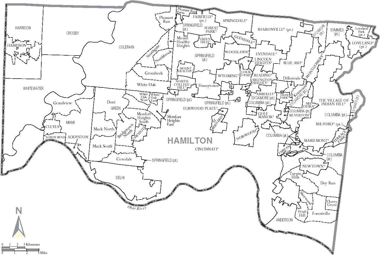
Note that it includes CDPs.
and here is my first draft at a route
Isn't Google Maps new feature of being able to auto drag and drop maps and directions cool! It's like they're listening right to me! This nearly eliminates the need for places like http://www.routebuilder.org and http://www.gmap-pedometer.com.
Each county in Ohio is broken up into (generally rectangularish) townships. Hamilton County has 12 townships. I believe there used to be 14, but Cincinnati Twp and Mill Creek Twp have been completely annexed by the city of Cincinnati. When a county was first formed / surveyed / whatever, it only had these townships as organizational units. As cities and villages are incorporated, land is taken away from the townships to form said cities / villages.
In very urban areas, this can lead to some odd township boundaries, or even removal of the township. As I mentioned before, there are 2 historical townships in Hamilton County that no longer exist. Or Columbia Township which now only exists in several small islands, since the rest of it has been annexed by other cities.
So, the list of places to visit:
Cities:
- Blue Ash
- Cheviot
- Cincinnati
- Deer Park
- Fairfield
- Forest Park
- Harrison
- Indian Hill
- Loveland
- Madeira
- Milford
- Montgomery
- Mount Healthy
- North College Hill
- Norwood
- Reading
- Sharonville
- Silverton
- Springdale
- St. Bernard
- Wyoming
Villages:
- Addyston
- Amberley Village
- Arlington Heights
- Cleves
- Elmwood Place
- Evendale
- Fairfax
- Glendale
- Golf Manor
- Greenhills
- Lincoln Heights
- Lockland
- Mariemont
- Newtown
- North Bend
- Terrace Park
- Woodlawn
Townships
- Anderson
- Colerain
- Columbia
- Crosby
- Delhi
- Green
- Harrison
- Miami
- Springfield
- Sycamore
- Symmes
- Whitewater
Now you might ask yourself: "Why Dan, I live in Mack, or Dillonvale or Finneytown - you missed my town on your list!!". And the reply of course is that you do not live there. You live in Green Township, or Sycamore Township, or Springfield Township (respectively). Those are what are called Census Designated places. Or, in other words, they just don't really exist, outside the minds of the people that live around there.
I have nothing against CDPs (other than that they would make my trip longer), but the problem with including them is that their borders are abstract and/or nebulous. To take some examples of some west-side Hamilton Co. neighborhoods. Where's the border between Mack North and Mack South. Or either of them and Bridgetown. Or Covedale, Dent, White Oak or Monfort Heights? You may think you know the exact border, but I guarantee you that out of 10 people, at least 5 would give different borders.
So, I have decided to stick with actual municipalities, with elected officers and official boundaries and such. Similarly, I chose to treat Cincinnati as just one city, rather than try to divide it up into neighborhoods - same kind of border problem. Maybe for my next trick I will visit every ward in Cincinnati (I believe there are 25).
And again, you might ask yourself: "Why Dan, Loveland and Milford are in Clermont County, not Hamilton, and Fairfield is in Butler County! I thought this was a Hamilton County thing?!?". Actually, most (local) people know that Loveland is partially in Hamilton County, as well as Clermont and Warren, as one of only 5 cities in Ohio that are in 3 counties. And Milford has a tiny sliver in Hamilton County, near the former terminus of the Little Miami Bike Trail. But Fairfield?!? Even the Wikipedia doesn't know it's partially in Hamilton County. In browsing the city's website as well as the county auditor's website, I am forced to agree that there is a tiny section (less than a block long) of Winton / Gilmore Road of Fairfield that is in Hamilton County - near 275 and the Cincinnati Mills mall.
Here is a map of the various places in Hamilton Co (click to enlarge)
Note that it includes CDPs.
and here is my first draft at a route
Isn't Google Maps new feature of being able to auto drag and drop maps and directions cool! It's like they're listening right to me! This nearly eliminates the need for places like http://www.routebuilder.org and http://www.gmap-pedometer.com.
Friday, June 29, 2007
Tour de Fairport Harbor 2007
So, in catching up on my blog posts, here's an update on the Tour de Fairport Harbor, 2007.
Basic "Every Street" rules can be found here
Fairport Harbor specific rules can be found here.
When thinking about this post, there's actually not a whole lot to say. My step-dad and I went out last Tuesday (June 19, 2007) to tour. Having already thought about the mechanics of the route, I had arrived with a route already in hand.
Tuesday morning we set out a little after 7 a.m. and then we rode the ride and that was... about it?
Our route ended up being 17.26 miles and the world record time is 1 hour, 38 minutes and 35 seconds. I think that it could probably be beaten - we weren't really cycling competitively - more just for fun and exercise. Plus my dad was doing silly things like stopping at stop-signs :-).
It was a nice way to see the town and see some of the sights
Thursday, June 28, 2007
Tour de Fairport Harbor ground rules
Ground rules for the Tour de Fairport Harbor, Ohio.
1. All rules as laid out in the basic ground rules must be followed:
2. The borders of Fairport Harbor are as follows:
3. Special cases
4. These streets are specifically not included
5. One-way streets:
1. All rules as laid out in the basic ground rules must be followed:
2. The borders of Fairport Harbor are as follows:
- Lake Erie to the north
- Grand River to the west, south and east (you must cross the river on OH-535 to the south and St. Clair St to the east
- East St to the east
- OH-535 to the east must be travelled to the city limits sign
3. Special cases
- Water St - You must travel north to the end of the street with the port authority building
- High St / Huntington Beach Dr - You must travel north to the guard shack admitting people into the park. You must travel on both sides of the "V" to the west of the guard shack as well as around the complete circle to the north of the shack.
- Houghton Ct - You must travel until the parking lot at the back (north) of the buildings
- House Ct - You must travel the entire street
- Prospect St (section off Vine St) - You must travel around the bend to the east - no need to travel down the foot path that goes down the hill to the west of Vine St
- Prospect St (section off East St) - You must travel around the bend until the Marina welcome sign.
- 2nd St - You must travel until the road dead-ends into the parking lot for an apartment-type building
- 3rd St - You must travel until the road splits into straight-ahead into the industrial building and off to the left into the condos.
- 4th St - You must travel into the section west of High St
- OH-535 - You must go eastbound until the city limits sign
- St. Clair St and OH-535 - You must cross the river
- OH-535 and High St - You must travel around all 3 sides of the triangle intersection between these 2 streets.
- Villa East Dr and Harbor Ridge Ln - You may travel between these streets by going around the chain barrier.
4. These streets are specifically not included
- Windjammer Ct
- Any pedestrian paths to the lake
- The driveway / roadway east of the guard shack at the Lakefront Park.
- The walkways inside Huntington Park
- Pincus Ct
5. One-way streets:
- Marine St - must be travelled northbound
- King St - must be travelled eastbound
- Paradise Alley / Paradise Ct - must be travelled eastbound
- 2nd St between High St and Water St - must be travelled westbound
- South St - On various online maps, this appears to be one-way westbound. But "on the ground" there were no markers to indicate as such. This was where one of the local schools was, so (since I'm not local) I don't know if this was a one-way thing only when school is in session? If so, the one-wayness must be observed. If there continue to be no markings when you attempt the record, you may travel it in either direction.
Tour de Madeira ground rules 2.0
Okay, as an update to the first draft and as a companion to the basic ground rules, here are the ground rules for Tour de Madeira 2.0
1. Rather than listing off every street, I will list out the various border streets and special cases. Where a specific side of the road is mentioned, the route must include riding / walking on that (Madeira) side of the street. Where the city border does not occur at an intersection of two streets, you must ride / walk past the Madeira city sign posted on that road before turning around. Any streets within these borders that are not specifically excluded must be visited
2. Special Cases - for some streets, it is unclear what actually consists of a "road". Or some roadways are definitely roads, but it's unclear where the border is between road and driveway. Some clarification for those cases.
3. These streets are specifically NOT included
4. There are no one-way streets within the tour limits
1. Rather than listing off every street, I will list out the various border streets and special cases. Where a specific side of the road is mentioned, the route must include riding / walking on that (Madeira) side of the street. Where the city border does not occur at an intersection of two streets, you must ride / walk past the Madeira city sign posted on that road before turning around. Any streets within these borders that are not specifically excluded must be visited
- Montgomery Road (from Hosbrook to Galbraith - SE side)
- Galbraith Road (from Montgomery to east of Miami - south side)
- Miami road (north of Galbraith - west side)
- Camargo road (both sides - from west of Blome to Madisonville)
- Shawnee Run road (from east of Madeira Hills Dr - north side)
- Kenwood Road (from south of Kenwood Hills to Euclid - both sides)
- Euclid Avenue (from Ken Arbre to Hosbrook - south side; east of Hosbrook - both sides)
- Ken Arbre Avenue (from Euclid to Stewart - south side)
- Stewart Avenue (from Woodsway Dr to Ken Arbre - east side)
2. Special Cases - for some streets, it is unclear what actually consists of a "road". Or some roadways are definitely roads, but it's unclear where the border is between road and driveway. Some clarification for those cases.
- Goff Terrace - From Miami to the Ferrari's parking lot
- Railroad Ave - From Miami past Center and into the first parking lot (7805 and 7809 Railroad)
- Dones Ave - From Camargo east of Marvin to where it splits into 2 driveways (going east to 7845 and south to 7825)
- Marvin Ave - From Dones to Sellman Park; no need to go past the Parking Lot
- Iuka Ave and Osceola Ave - at the south ends of both of these streets, there are triangular "median" type structures. You must travel around all three sides.
- Paisley Lane - You must go around the corner until the road dead ends into the driveway for 6680 Paisley
- May St - You must go all the way to 6600 and 6609
3. These streets are specifically NOT included
- Any of the streets of the mobile home park on Dawson Road
- Greylock Drive
- Any "named" streets on the campuses of any of the schools
- Shawnee Pines Drive
- Dot Ave
- Miami Road south of Shawnee Run road
- "Extended" driveways, such as 6873-6929 Fox Hill Lane
- The path through Sellman Park to Fox Chase Lane - though you are allowed to travel that if you feel that would be advantageous
- The narrow separate pedestrian walkway at the south end of Rita Avenue. You still have to travel all of Rita, but you do not have to especially go through this walkway as you do with the medians on Iuka and Osceola
4. There are no one-way streets within the tour limits
Every Street ground rules 1.0
After the first draft, I've thought of some updates to the Tour de Madeira ground rules. While planning the T de M 2007, I thought of some areas that might need clarification. Also, after doing the Tour de Fairport Harbor, I also realized that there was a need (yes, a NEED) for a set of abstract ground rules for things that are common to all tours of this sort (like generic rules for how to handle cul-de-sacs or intersections or borders), as well as tour-specific ground rules (like a listing of streets / borders for a specific tour). So this post will contain the generic rules. Further posts will come (soon?) with Madeira rules 2.0 as well as the Fairport Harbor ground rules, and of course a report of T de FH '07.
1. The full length of every street within the tour's ground rules must be visited, but you are allowed to go outside of the tour limits if you want. Official time is from start to finish, and includes any break or rest time. You are allowed to ride or walk your bike on each street. You may travel on the sidewalk if it is convenient, but travelling on the sidewalk does not count towards completing the route. Except where specifically excluded, travelling through any part of an intersection between two streets counts as visiting the entire intersection. To count a segment of road as "completed" you only have to ride on one side of the street, though of course, you can choose to ride on both sides, if you deem it to be advantageous.
2. When going down cul-de-sacs, you must make an effort to "round the bend", but you do not have to scrape the curb. Similarly, when travelling to the end of a particular intersection, you do not have to go into the cross street to "fully" complete the street you are on, as long as a reasonable effort is made to get to the end of the street.
3. If there are any one-way streets (or one-way sections of particular streets) within the tour limits, you must travel them in the correct direction.
Friday, June 15, 2007
Tour de Fairport Harbor planning
Yes folks and loyal readers and viewers, it is another post from me, Dan Miller, your host in the crazy world of every whatever adventures. Or should that be Every Whatever adventures? After a few guest posts, we are back on the saddle. So no need to be confused about wondering why I'm going to be riding 63 buses in Houston, leaving my family and making all these plans without telling you. I don't know if anyone is sick of reading about Houston buses (I can only speak for myself in saying that I never tire of such talk) but this post is going to be bringing it back home to the Buckeye State.
Frankly, I don't know why I didn't think of this earlier. Sometime this summer we are going on vacation to the lovely 'burg of Fairport Harbor, Ohio. So recently I got the idea for TOUR DE FAIRPORT HARBOR 2007!!!! MWAHAHAHAHAHAHAH!!!!!
Okay, calming down now. FH is a pretty small town. Don't worry, further bulletins as events warrant, but I think it can be done in somewhere around 20-30 miles, maybe even less.
Because it's much smaller than Madeira, I am taking a more systematic approach. FH is mostly just in a grid layout, but it does have some wrinkles laid in. First I tried to figure out exactly where the boundaries of the village lie. This was actually a bit more complicated than I wish that it had been. I primarily used the Lake County auditor's website to try and figure it out. Using home sales as well as searches, I was able to (I think) come up with a fairly close enough boundary system. If you look at a map of Fairport Harbor, I am saying that, starting in the NW at Lake Erie and the Grand River, the border follows the Grand River south (on the east side of the river), then follows OH-535 north, with the village border continuing to follow East St. north (and also including the dead-end sections to the east of East St, such as Joughin St, York St, 3rd St, etc). I think this will be close enough to allow me to come up with a route, pending some investigation when I get there.
Some topics to research - where on OH-535 does FH start - at the river or slightly before / after? I did see that Windjammer Ct, just to the south of the river, is in Painesville Township. What about any part of N St Clair St, or any sections of OH 535 east of East St. What about Huntington Beach Drive - driveway to a park, or road? Then there's the always fun game of "Is this a road, or someone's driveway?"
So, now on to a bit of technical analysis of the problem. What we're looking for here is called an Eulerian path. That is, in technical terms, a path in a graph which visits each edge exactly once. Now we are not constrained in having to only visit each edge once, but obviously if we were able to do so, that would minimize our total distance, which IS the goal.
To find an Eulerian path through a graph (or in this case a road system), each vertex must have an even degree. Or, in other words, each intersection must have an even number of roads in it. So, 4-way intersections (or 6-ways!) are good, while T-intersections (3-way) or 5-ways are not.
I think it would be difficult to find a road system where this was the case, and Fairport Harbor is no exception. After printing out a map, I started plotting the "odd degree" vertices. To make the graph capable of containing an Eulerian path, you have to insert artificial edges between the odd degree vertices, thus making them even.
Note that for purposes of this experiment, I ignored dead-end / culdesac entries, since in those cases it is clear that you will have to do an out and back, which will turn it into even. As an example of this, take East St and Joughlin St (a dead-end st). It's currently a T-intersection (3 vertices or odd). But (barring starting or stopping the route on Joughlin), when you approach the intersection on East St. you will go out and back on Joughlin, creating a 2nd "edge" there, making it have 4 vertices or even. If this is not making sense to you, you should probably just go ahead and stop now (if you haven't already). An example of an odd vertex that we want to count is something like High St and Orchard St, or High St and King St.
So with that condition, I originally came up with 18 odd vertices. So it seemed simple that all I would have to do is connect them with 9 "extra" edges and I would have my path. But on further review, I realized that I was missing some instances where the out and backs on cul-de-sacs would throw things off. Just like doing an out and back on a cul-de-sac causes a 3-way intersection to be turned into a 4-way (and thus even and good), the out and back on a 4-way intersection causes it to be turned into a 5-way (and thus odd and bad). An example: East St and 3rd St. It's a 4-way intersection, but because you have to travel out and back on the section of 3rd st east of East St, that causes it to be a double edge and makes the vertex of East and 3rd into a 5-way.
So, when taking that into account, it comes up to 36 edges. While I'm sure it's just a coincidence that this is exactly twice the number, I'm not sure if it HAS to be an even number or not. I was trying to figure out what I would do if there was an odd number, but I'm not sure if it by definition HAS to be even or not. In any case, I just have to come up with 17 artificial edges, and the 17 that have the shortest distance, and I'll have my route. Note that it is 17 and not 18 because 2 of the odd vertices will be my starting and stopping points.
I will post later if/when I come up with a route, and of course a post for the report.
Monday, June 04, 2007
Computer Programs and the (now) 63-Bus Ride
Yes, the new METRO schedule change is out, and they split Bus 8 (South Main/Yale) into Bus 8 South Main to the south and Bus 66 Yale to the north. So now that makes 63 buses I have to ride. I had better get going on this before they change it again!
I managed to get all the bus times (post-bus 8 split) and threw them all into a database. I've been trying my hardest to use this data to my advantage to find an optimal route. In my mind, an optimal route would be one where I would have at least a 10 minute wait between buses (to avoid the late bus factor) and no more than a 30 minute wait between buses.
My first script did just that. You gave it a starting spot and how long you wanted to wait, and it spit out a route for you. You could either have it spit out the first route found or the fastest route found. The problem with this is processing speed. In order to find every bus route possible, it is a worst case of 63! calculations (63! means 63 factorial, or 63*62*61*60* ... *3*2*1). If you throw that into a calculator, it comes back with 2 X 10^82, or a 2 with 82 zeros after it. This means that even if I had a super computer that could do a billion checks a second (which is unreal speed), it would take 3 X 10^67 years to calculate a solution. So... that won't work.
My second script was to cut it down into little pieces to aid in a human-aided search. You could put in point A and point B and it would try to find the best path between them. The script works, to a point. The problem is that it usually skips over some crosstown buses that you need to get, because it would take too long to get them later. But it does very good at finding quickly the fastest path using 3-4 buses between two points. At least that's something. I also added a user-input variable for a "first bus" that you have to take, as well as an exclusion list of buses that you may not take on your trip. Another problem with the script is that there is no advanced string matching for the starting point, so if you don't spell the street name exactly like it is in the database, it won't know what you're talking about.
My next script is going to be 100% user input. I think this will be the best help in finding a good route. When you give it a starting point, it will spit back at you all the routes that go through that point. When you pick one of those routes, it will spit out every stop along that route, including what times it will get to that route, and which buses intersect it at that route and how long you'd have to wait at that stop to hit that bus. Then you click one of those stops and the process repeats. It will keep a running tab of what buses you've taken to get to where you're going and let you back up as many spots as you need. Unfortunately, I probably won't get to this until after my vacation next week.
Thursday, May 24, 2007
Making the Most of the 62-Bus Ride
First of all, a correction to my original post. There are 62 local buses in Houston, not 61. I grouped buses 26/27 together. If you look at a map, they're pretty much the same line. They go around in a circle around downtown. Bus 27 goes clockwise and bus 26 goes counterclockwise. But, they have different numbers, so I'll consider them different lines.
I think the biggest question I get asked about riding every bus in Houston is "why?" I think the biggest reason is: adventure. It's the same reason that someone would drive 3 days cross-country when they could of just taken a 5-hour flight. It's the same reason you can't help but slow down to look at a car crash. It's a break from the ordinary. With every adventure comes a story; a story you can tell others. A story you can tell your friends and family. I mean, what is my alternative? Spending all day making copies and staring at a computer screen? Besides, I never give up a chance to promote public transportation. You can ask any of my co-workers that and they would tell you the same thing!
But is this enough? I think so. But, if this adventure ends up getting press, I'm going to try to do something charitable. I would seem like a waste not to. I'm a good person, after all! Yesterday METRO released a news article that 10 of their mechanics were putting away $3 of each of their paychecks into a fund to buy bicycles for Houston's Fifth Ward kids for Christmas. Last year they managed to buy 58 bicycles. This year they are hoping to buy 500 bikes with help of donors. I think this is an amazingly worthwhile cause. What I'm going to do is try to set up a way to accept pledges to go towards this fund, where people can pledge a per-bus donation for my big trip, then an optional bonus if I can finish the entire thing. This way, even if I don't make it, I will still raise money for charity. Every dollar I collect will go towards buying those kids these bikes. They will compliment all the new bike racks that METRO is putting on their buses quite nicely.
Wednesday, May 23, 2007
Houston buses
In case you aren't monitoring the comments for posts that were written 6 months ago, I thought I would clue you in on a recent development. Yesterday I got a new comment on this post
I have inspired someone else!!! Fellow is going to attempt to ride all 61 local buses in Houston. Follow the link for more information.
It's almost enough to make me want to go down to Houston to ride with him :-). And just think of how many counties I could pick up travelling down there!!
I had considered doing something similar in Cincinnati but shelved the idea. The problem is that just about every bus in Cincinnati goes from downtown to somewhere. There are only a few (51, 41, and probably a few others that I can't think of off the top of my head) that are more of "cross-town" buses. So that's not really a problem for completing the route - actually it would make it pretty easy. All you'd need to do (for the most part) is just get on and off various buses downtown, which just didn't seem as "cool" as some of the other things I had come up with. A larger city with more buses (Chicago and New York to name 2) I think would be a worthwhile challenge. Still maybe this will inspire me to come up with a good route for Cincinnati.
Tuesday, May 01, 2007
Cuyahoga Libraries
Did you ever think that there could me MORE library posts?!!?
When I was out driving to Chicago for the second time, I got calls from various family members along the way. That would be mostly due to the fact that it was my birthday. I appreciated the well-wishes, but while talking to my step-dad, he was mentioning how he had seen my post about visiting every library in Hamilton County, and wondered what the possibilities would be for doing every library in Cuyahoga County.
This has spent some time being tickled about in the back of my mind, but I got some time the other day to work it out.
Unfortunately, I don't have my system quite completely automated (though it's automated enough that it does take a lot of the grunt work out of doing things). One of my problems is that the program that I have (that I downloaded) only finds the shortest solution for a closed loop (i.e. starting and ending at the same place). That's not quite what we're going for here, so I have to manually pick the starting and ending points. I try to do that logically and I pick out several different start/end points and run the program, and take the one with the shortest distance.

There's a map of the shortest route that I was able to find, 109.7 miles. No matter where else I started or ended, I couldn't find anything better. Most of the ones I checked were in the low 110s, so this is probably pretty close if not the fastest.
A few notes: From looking at the map, it seems like ending North Olmsted, Fairview, Bay would not be faster than ending N.O., Bay, Fairview, but comparing the distances is 10.7 for the first (4.2 from N.O.-Fairview and 6.5 for Fairview-Bay) and 11.7 for the second (5.2 for N.O.-Bay and again, 6.5 for Fairview-Bay)
Unlike the Cincinnati libraries, which seem to have variable start-end days by branch, all of the Cuyahoga libraries have hours from 9 a.m.-9 p.m., Monday-Thursday. So that gives a full 12 hours to do the ride, which seems doable (though not by much if at all). That's in contrast to Cincinnati, which has a shortest distance of 121 miles (for 42 libraries) and only 9 hours to do it (due to the different branch open and close times)
The only exception to those hours is the Richmond library, which has hours of 10-6. So that would require doing this route starting at Gates Mills, but even so, you'd probably still have to wait for Richmond to open at 10, since the first 2 legs (Gates Mills-Mayfield and Mayfield-Richmond) are only 4.8 and 2.1 miles (i.e. they would probably take you less than an hour, even considering book-checking out times). So logistically, it may be better to choose a slightly longer distance that would put Richmond further than 3rd. Though when you're riding 110 miles, you don't want to put TOO many more on there :-)
We shall see if this becomes a reality. One problem is that it would require a day of vacation (at least - possibly 2 to recover). I think maybe a Thursday ride would be the best option, with a long weekend to recover. Do I hear Thursday, July 3, 2008??
Tuesday, April 17, 2007
On the way home
On Wednesday morning, one of the first things I did was check out the weather. I couldn't help it as I walked out of the hotel in the morning to find snow. Yes, it is still April. Weather.com had a snow advisory for much of central Wisconsin, with areas like Madison expecting 7-10 inches.
Ouch. Luckily my class was only a half-day on Wednesday, so I was able to get an early start. I think that if I had left in the afternoon the combination of regular Chicago rush hour with all the snow would have just been murder. As it was, the Interstates were certainly not clear - there was stop and go traffic as I made my way from downtown out I-90 westbound into Wisconsin. One downside of having picked up a bunch of these southern Wisconsin counties in previous trips is that it took me about 3 hours (and about 175 miles) before I hit my first "new" county - Marquette (#51). A few miles later, I exited I-39 north and headed east on WI-23. It was about a 16 mile one-way jaunt to pick up Green Lake (#52), but there was no other better way to do it. If you look at the Wisconsin county map, you can see that most of the counties are twice the size of Marquette and Green Lake. I'm not sure why they decided to split them so small, but it's annoying. I had looked for ways to cut out some mileage on the way back by diagonally getting to I-39 one exit further north (either by county roads or a jaunt on WI-22), but with the snow, I decided to just go back the way I came.
Continuing on I-39, I sauntered through Waushara (#53) and Portage (#54) before setting out for my 2nd out and back of the day, this time on County Road W, westbound to pick up Wood (#55). The road itself was not too bad (you could typically do 30-40 mph), but there were MAJOR snow drifts on parts of the road that made driving "interesting". At CR U, I turned right and did a little British-style driving to make sure I was in Wood. Driving through Kellner, WI, I got myself a bit unsure of where I was headed, but stayed the course and found myself on WI-54 eastbound, headed back to I-39. In Plover, I stopped to refuel and get some Wendy's. Here you can see a bit of the weather I was dealing with:

Somwhere in Plover, I first started seeing signs that WI-54 was closed for construction. As I started looking at the map to try and find an alternate route, I saw another sign that listed that it was open to I-39. Since that was as far as I was taking it, I breathed a sigh of relief. Continuing on I-39 and then US-51 northbound picked up Marathon (#56) and Lincoln (#57). In Merrill, US-51 ends its limited-access-ness (at least according to Mapquest), and I took the last "exit" to WI-64 and then WI-17, and headed northeasterly. After about 20 miles I got into Langlade county (#58) and I started looking for my turnoff on to CR Q. Just after the county line, I saw a turnoff to the right, but I continued straight because I was expecting to go left. It took me about a 1/2 mile or so to realize that I had missed my turn. Within a few miles I picked up another county, Oneida (#59), and after one near false-start, successfully navigated my way around the northern side of Pelican Lake to US-45. I believe it was here that I saw a sign for a "Church of Jesus Christ Restoration Branch". My first reaction was that this was some sort of LDS splinter group. I tried to do some Googling to verify this hypothesis, but was unable to confirm. So, either it's some other similarly named church, or it's just too small for me to find (I mean this was a hand-made sign staked up on a dirt road in the middle of nowhere...)
CR Q goes around the north side of Pelican Lake, with CR G going around the south side. Both dead-end into US 45, but about 6 miles apart. Since I was heading north, CR Q seemed like the logical bet, but the online mapper had suggested CR G. I wasn't sure if that was a particular reason or not (like CR Q didn't really exist or was in crappy condition?) but when I got to the T-intersection at the west side of the lake, there were signs pointing left for US 45 north and right for US 45 south, so I took CR Q around the north side. It wasn't a problem, except for the general snowiness.
A few miles north, I did an out and back on US 8 to pick up Forest (#60) and then continued for another hour or so north on US 45, picking up Vilas (#61) and then on into Michigan. Ahhhh the good ol' U.P. Before this little trip, the sum content of my knowledge of the UP consisted of the fact that my aunt Bonnie was originally from there, and that Michigan was forced to accept it in exchange for a strip of land on the Ohio border following the Toledo War. That may be a slight exaggeration. I continued on US 45 into Gogebic (#62) and Ontonagon (#63) counties, then took M-26 into Houghton county(#64). In the city of Houghton, I crossed the Portage Lake Lift bridge over the Portage waterway. I did not notice this when I crossed (it being dark), but from the Wikipedia page and picture, it appears that in the summer, the bridge raises to an intermediate level to allow boats to cross under while still maintaining road traffic. After crossing over into the town of Hancock, I turned left onto US-41 and followed that north to Keewenaw (#65). There was not a county welcome sign (that I saw anyways). My map had me looking for the "town" of Kearsarge, which I did not see. I should have been looking for Allouez (which was on my map but I just didn't notice it). I passed through there and when I got to Mohawk, MI, I saw that it was definitely in Keweenaw county, so I turned around. There was a welcome sign for Houghton County going southbound though. I followed US-41 back the way I came, back over the bridge, and then into Baraga (#66). At this point, it was about 1:30 a.m. CDT, and I was feeling a bit tired, so I pulled into some gas station and took a little nap. I ended up sleeping for about an hour and then set on. No more than a minute after I was back on the road, I passed into Marquette (#67). A few miles later, I turned right on to M-95 and made my way into Dickinson (#68) and then an out and back on M-69 West into Iron (#69). The original plan had me then taking M-69 east, but I found that it was a much better option to continue on M-95 south into Iron Mountain, and then make 2 short out and backs on US-2 West and US-141 South to pick up the final 2 Wisconsin counties on my trip, Florence (#70) and Marinette (#71). Trying to get these couunties from the Wisconsin side would have added significantly more time to my trip.
Back in Michigan on US-2 eastbound, I travelled uneventfully into Menominee (#72) and Delta (#73) into the city of Escanaba. I then rejoined US-41, this time going northbound, into Alger (#74). Then it was M-67 northbound, and just before I made the turn on to M-94 east, I pulled into another parking lot to take a nap. At this point it was about 5 a.m. (EDT now). I slept for about an hour again, and when I woke up and tried to pull out, the wheels just spun. I had been able to pull in due to my initial momentum, but with 3-5 inches of snow on the ground, I wasn't going anywhere from a standstill. I tried forward and reverse, but nothing. By now it was light out, and there were some cars driving by as I surveyed my options. I put it in neutral and got out of the car (it was still snowing lightly). I rocked the car back and forth a bit. Of course I couldn't move it by myself, but I moved it a bit. I got back in and I don't know if it was that or something else, but I was able to put it in reverse and spin myself a bit backwards, and then once I put it in drive I started going. Phew.
After a brief jaunt on M-94, I began an 80 mile trip on M-28 eastbound, through Schoolcraft (#75), Luce (#76) and Chippewa (#77), then M-123 to Mackinac (#78) and finally on to I-75 southbound. By this time, I was running kind of low on gas so I kept a lookout for gas stations. I figured there might be one at the onramp to 75, but nope. I crossed over the 2-mile Mackinac Bridge and my Upper Peninsula became AWFUL BLUE. The bridge was pretty cool. I was going to take a picture but you know, I've done that before and it just doesn't come out very exciting. Still, travelling between Lake Michigan and Lake Huron was kinda neat. The very first exit in the Lower Peninsula had a Shell station, but I couldn't tell if there was re-entry to 75, so I didn't stop. As I passed by, it did look like there was, but it was hard to tell since the interchange was an odd design. Passing through Emmet (#79) and Cheboygan (#80), I remained on the lookout for gas stations. The next 3 exits (about 20 miles) had no services! Finally, I was able to score some at the M-68 exit. The Interstate itself was not plowed very well - I was actually behind a pair of plow trucks, but even behind them it was still barely one lane wide. Inside the gas station, I took a pic of one of my favorite grammatical mistakes

At this point, I decided to punt on part of my plan. Originally, I was going to continue down 75 a bit to do an out and back to the west, picking up Otsego, Antrim and Charlevoix counties before heading east, but I decided that those counties would still be there later (deep breath), and in an effort to get home a little earlier, I instead headed east on M-68 into Presque Isle County (#81) and shortly thereafter, went south on M-33 into Montmorency (#82). From here on, the roads were pretty clear. I'm not sure if the more southern parts of Michigan just didn't get as much snow, or if I just gave the snowplows enough time to clear it out. I spent some time trying to find CR 624, which was going to cut off a few miles by taking a more direct route to M-32 east. With the snow, I debated whether or not to just stay on M-33 to M-32, but in the end stuck with the plan and went with the county roads. The county roads were not plowed as well (but still not that bad) - I think that in normal weather, taking these county roads would definitely be worth it, but with the snow, it was probably about a wash.
Just east of Hillman, I made it to M-32 and Alpena (#83) and then followed M-65 south into Alcona (#84). A brief out and back on M-72 got me Oscoda (#85) and then back on to M-65 into Iosco (#86) and Arenac (#87). Somewhere in here, I took my 3rd nap of the day, at a Shell station. Afterwards, I turned westbound on to Maple Ridge road which took me close to I-75. Before getting on the Interstate, I did an out and back south and northbound to pick up Ogemaw (#88) and Gladwin (#89). On I-75 southbound, I saw a sign

This is actually a replica that I found online from some other prison, but that's what it said (more or less). I took I-75 through Bay (#90) to M-84, which I followed southbound into Saginaw (#91). Turning around just south of the county line, I encountered my first instance of a Michigan left interchange. On the road, I thought that this was a new type of intersection which I had recently read about (a Continuous flow intersection), but it appears that these are different (though similar) types of interchanges. The Michigan left has been around for about 40 years, and is named that because it's not very common except for in (wait for it) Michigan. I saw several of these, especially later in the day as I went through Detroit.
Back on M-84 north, I skirted the southern edge of Bay City, where, hearkening back to the prison sign I saw earlier, I saw a billboard mentioning a wanted criminal named (I kid you not) Lando Calrissian Jones. East of the city, I passed a Meijer and made my way to M-25, which I took into Tuscola (#92). At Unionville, when M-25 headed north, I continued straight on Bay City-Forestville Road, which I took into Sanilac (#93). A brief out and back on M-53 picked up Huron (#94) and then I continued on M-53 south for 50 miles into Lapeer (#95). At Almont, MI, I did an out and back on Almont Road to pick up St. Clair (#96). I got lucky there as the road was not well marked in the city limits, so I took a guess as to which road was going to turn into the road I needed. Back on M-53 I entered Macomb (#97) for my final (new) county of the day. On the entry to Detroit, I passed by 32 mile road, which was the first time I noticed the Mile road numbering system, the most famous of which is 8 Mile.
From then, it was just a trip home on I-75. I did take my 4th and final nap of the day just over the Ohio border in a Meijer parking lot. Of cousre I stopped in first to check if there were any good sales for the week! I ended up getting home just after 11, so with the exception of my 4 hour-long naps, and taking the time zone into account, I was driving for 34 consecutive hours.
Subscribe to:
Posts (Atom)